You are here: Home > Network List > GS - US Geological Survey Networks Stations List
> Station DEC12 Decatur Surface Seismic Site, Decatur, IL, USA > Earthquake Result Viewer
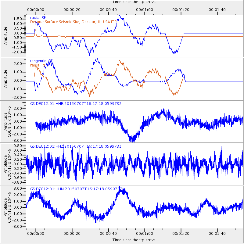
DEC12 Decatur Surface Seismic Site, Decatur, IL, USA - Earthquake Result Viewer
*The percent match for this event was below the threshold and hence no stack was calculated.
| Earthquake location: |
Central East Pacific Rise |
| Earthquake latitude/longitude: |
-13.4/-111.3 |
| Earthquake time(UTC): |
2015/07/07 (188) 16:08:03 GMT |
| Earthquake Depth: |
10 km |
| Earthquake Magnitude: |
5.7 MWW, 5.7 MWC |
| Earthquake Catalog/Contributor: |
NEIC PDE/NEIC COMCAT |
|
| Network: |
GS US Geological Survey Networks |
| Station: |
DEC12 Decatur Surface Seismic Site, Decatur, IL, USA |
| Lat/Lon: |
39.91 N/88.91 W |
| Elevation: |
208 m |
|
| Distance: |
57.0 deg |
| Az: |
20.457 deg |
| Baz: |
206.243 deg |
| Ray Param: |
$rayparam |
*The percent match for this event was below the threshold and hence was not used in the summary stack. |
|
| Radial Match: |
30.540667 % |
| Radial Bump: |
400 |
| Transverse Match: |
43.12902 % |
| Transverse Bump: |
400 |
| SOD ConfigId: |
1085051 |
| Insert Time: |
2015-08-11 20:42:52.709 +0000 |
| GWidth: |
2.5 |
| Max Bumps: |
400 |
| Tol: |
0.001 |
|
Signal To Noise
| Channel | StoN | STA | LTA |
| GS:DEC12:01:HHZ:20150707T16:17:18.059973Z | 1.1026232 | 2.5874755E-7 | 2.3466542E-7 |
| GS:DEC12:01:HHN:20150707T16:17:18.059973Z | 4.532055 | 2.594113E-6 | 5.7239225E-7 |
| GS:DEC12:01:HHE:20150707T16:17:18.059973Z | 2.242271 | 1.1379527E-6 | 5.0750015E-7 |
| Arrivals |
| Ps | |
| PpPs | |
| PsPs/PpSs | |


