You are here: Home > Network List > TA - USArray Transportable Network (new EarthScope stations) Stations List
> Station Z41A Richland Creek Farm, El Dorado, AR, USA > Earthquake Result Viewer
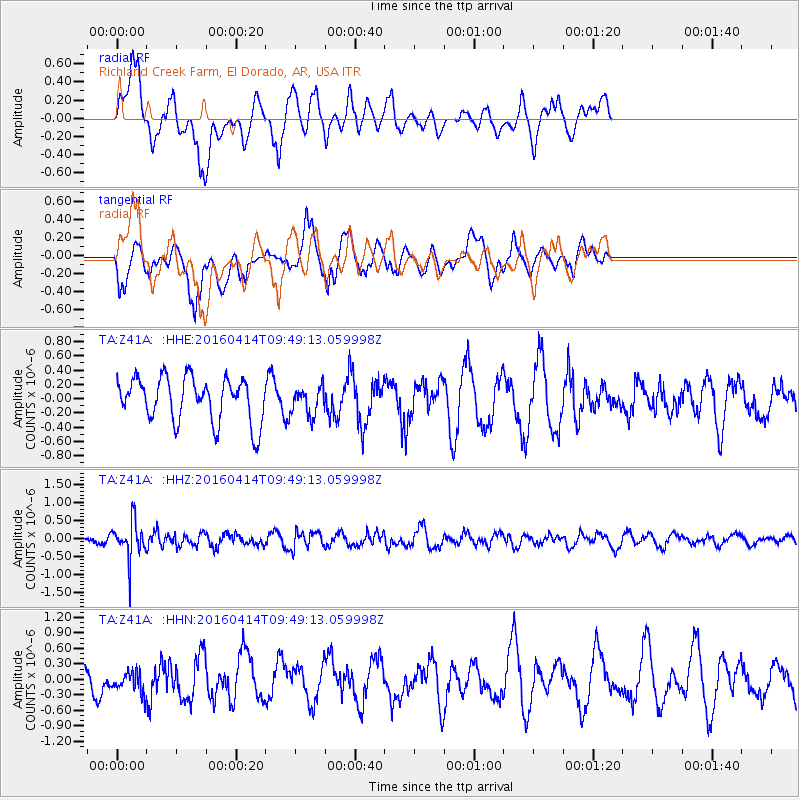
Z41A Richland Creek Farm, El Dorado, AR, USA - Earthquake Result Viewer
*The percent match for this event was below the threshold and hence no stack was calculated.
| Earthquake location: |
Chile-Argentina Border Region |
| Earthquake latitude/longitude: |
-33.9/-70.4 |
| Earthquake time(UTC): |
2016/04/14 (105) 09:38:44 GMT |
| Earthquake Depth: |
112 km |
| Earthquake Magnitude: |
5.5 MB |
| Earthquake Catalog/Contributor: |
NEIC PDE/NEIC ALERT |
|
| Network: |
TA USArray Transportable Network (new EarthScope stations) |
| Station: |
Z41A Richland Creek Farm, El Dorado, AR, USA |
| Lat/Lon: |
33.26 N/92.80 W |
| Elevation: |
62 m |
|
| Distance: |
70.0 deg |
| Az: |
340.154 deg |
| Baz: |
160.295 deg |
| Ray Param: |
$rayparam |
*The percent match for this event was below the threshold and hence was not used in the summary stack. |
|
| Radial Match: |
56.061943 % |
| Radial Bump: |
400 |
| Transverse Match: |
59.76047 % |
| Transverse Bump: |
400 |
| SOD ConfigId: |
7422571 |
| Insert Time: |
2019-04-22 05:59:36.042 +0000 |
| GWidth: |
2.5 |
| Max Bumps: |
400 |
| Tol: |
0.001 |
|
Signal To Noise
| Channel | StoN | STA | LTA |
| TA:Z41A: :HHZ:20160414T09:49:13.059998Z | 3.0390723 | 5.121419E-7 | 1.6851916E-7 |
| TA:Z41A: :HHN:20160414T09:49:13.059998Z | 0.4944372 | 2.2800518E-7 | 4.6114084E-7 |
| TA:Z41A: :HHE:20160414T09:49:13.059998Z | 0.658294 | 2.0446242E-7 | 3.1059437E-7 |
| Arrivals |
| Ps | |
| PpPs | |
| PsPs/PpSs | |


