You are here: Home > Network List > AU - Australian Seismological Centre Stations List
> Station WRKA Warrakurna, Western Australia > Earthquake Result Viewer
WRKA Warrakurna, Western Australia - Earthquake Result Viewer
| Earthquake location: |
Vanuatu Islands |
| Earthquake latitude/longitude: |
-14.5/166.5 |
| Earthquake time(UTC): |
2016/04/14 (105) 12:17:05 GMT |
| Earthquake Depth: |
10 km |
| Earthquake Magnitude: |
6.0 MO |
| Earthquake Catalog/Contributor: |
NEIC PDE/NEIC ALERT |
|
| Network: |
AU Australian Seismological Centre |
| Station: |
WRKA Warrakurna, Western Australia |
| Lat/Lon: |
25.04 S/128.30 E |
| Elevation: |
622 m |
|
| Distance: |
37.3 deg |
| Az: |
247.676 deg |
| Baz: |
81.007 deg |
| Ray Param: |
0.07620233 |
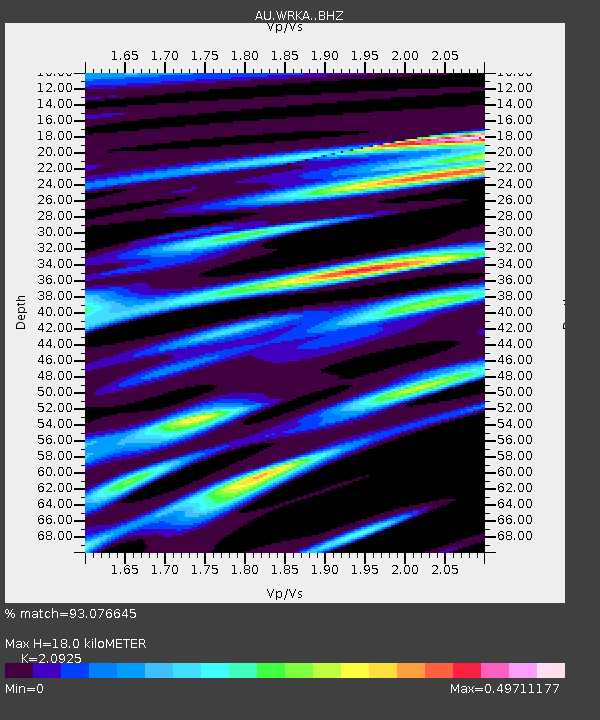
| Estimated Moho Depth: |
18.0 km |
| Estimated Crust Vp/Vs: |
2.09 |
| Assumed Crust Vp: |
6.51 km/s |
| Estimated Crust Vs: |
3.111 km/s |
| Estimated Crust Poisson's Ratio: |
0.35 |
|
| Radial Match: |
93.076645 % |
| Radial Bump: |
245 |
| Transverse Match: |
57.32841 % |
| Transverse Bump: |
400 |
| SOD ConfigId: |
7422571 |
| Insert Time: |
2019-04-22 06:04:07.019 +0000 |
| GWidth: |
2.5 |
| Max Bumps: |
400 |
| Tol: |
0.001 |
|

Signal To Noise
| Channel | StoN | STA | LTA |
| AU:WRKA: :BHZ:20160414T12:23:47.218994Z | 6.31741 | 9.848949E-7 | 1.5590169E-7 |
| AU:WRKA: :BHN:20160414T12:23:47.218994Z | 1.5684347 | 2.3288342E-7 | 1.4848143E-7 |
| AU:WRKA: :BHE:20160414T12:23:47.218994Z | 11.042884 | 6.6129166E-7 | 5.9883966E-8 |
| Arrivals |
| Ps | 3.2 SECOND |
| PpPs | 8.0 SECOND |
| PsPs/PpSs | 11 SECOND |


