You are here: Home > Network List > TA - USArray Transportable Network (new EarthScope stations) Stations List
> Station A21K Barrow, AK, USA > Earthquake Result Viewer
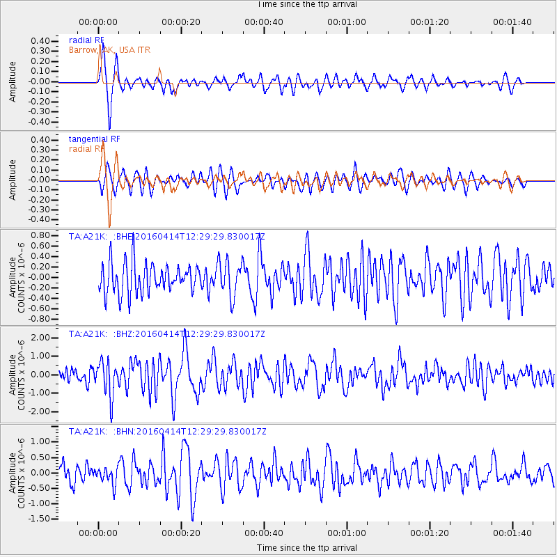
A21K Barrow, AK, USA - Earthquake Result Viewer
*The percent match for this event was below the threshold and hence no stack was calculated.
| Earthquake location: |
Vanuatu Islands |
| Earthquake latitude/longitude: |
-14.5/166.5 |
| Earthquake time(UTC): |
2016/04/14 (105) 12:17:05 GMT |
| Earthquake Depth: |
10 km |
| Earthquake Magnitude: |
6.0 MO |
| Earthquake Catalog/Contributor: |
NEIC PDE/NEIC ALERT |
|
| Network: |
TA USArray Transportable Network (new EarthScope stations) |
| Station: |
A21K Barrow, AK, USA |
| Lat/Lon: |
71.32 N/156.62 W |
| Elevation: |
577 m |
|
| Distance: |
89.2 deg |
| Az: |
11.156 deg |
| Baz: |
215.565 deg |
| Ray Param: |
$rayparam |
*The percent match for this event was below the threshold and hence was not used in the summary stack. |
|
| Radial Match: |
77.39921 % |
| Radial Bump: |
400 |
| Transverse Match: |
61.406673 % |
| Transverse Bump: |
400 |
| SOD ConfigId: |
7422571 |
| Insert Time: |
2019-04-22 06:07:07.698 +0000 |
| GWidth: |
2.5 |
| Max Bumps: |
400 |
| Tol: |
0.001 |
|
Signal To Noise
| Channel | StoN | STA | LTA |
| TA:A21K: :BHZ:20160414T12:29:29.830017Z | 2.7880719 | 9.4162573E-7 | 3.3773367E-7 |
| TA:A21K: :BHN:20160414T12:29:29.830017Z | 0.9583502 | 2.656513E-7 | 2.7719648E-7 |
| TA:A21K: :BHE:20160414T12:29:29.830017Z | 1.1923875 | 3.3961774E-7 | 2.8482162E-7 |
| Arrivals |
| Ps | |
| PpPs | |
| PsPs/PpSs | |


