You are here: Home > Network List > TA - USArray Transportable Network (new EarthScope stations) Stations List
> Station J26L Joseph Creek, AK, USA > Earthquake Result Viewer
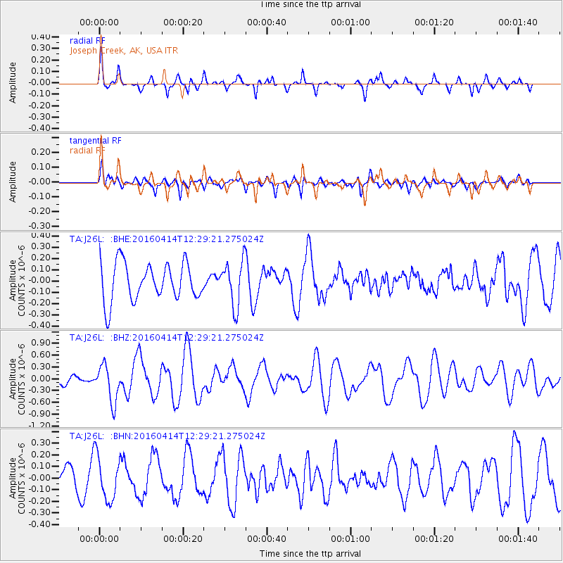
J26L Joseph Creek, AK, USA - Earthquake Result Viewer
*The percent match for this event was below the threshold and hence no stack was calculated.
| Earthquake location: |
Vanuatu Islands |
| Earthquake latitude/longitude: |
-14.5/166.5 |
| Earthquake time(UTC): |
2016/04/14 (105) 12:17:05 GMT |
| Earthquake Depth: |
10 km |
| Earthquake Magnitude: |
6.0 MO |
| Earthquake Catalog/Contributor: |
NEIC PDE/NEIC ALERT |
|
| Network: |
TA USArray Transportable Network (new EarthScope stations) |
| Station: |
J26L Joseph Creek, AK, USA |
| Lat/Lon: |
64.50 N/143.56 W |
| Elevation: |
1144 m |
|
| Distance: |
87.4 deg |
| Az: |
19.373 deg |
| Baz: |
227.923 deg |
| Ray Param: |
$rayparam |
*The percent match for this event was below the threshold and hence was not used in the summary stack. |
|
| Radial Match: |
54.37606 % |
| Radial Bump: |
304 |
| Transverse Match: |
56.4968 % |
| Transverse Bump: |
400 |
| SOD ConfigId: |
7422571 |
| Insert Time: |
2019-04-22 06:07:16.977 +0000 |
| GWidth: |
2.5 |
| Max Bumps: |
400 |
| Tol: |
0.001 |
|
Signal To Noise
| Channel | StoN | STA | LTA |
| TA:J26L: :BHZ:20160414T12:29:21.275024Z | 3.5700128 | 4.8182136E-7 | 1.3496347E-7 |
| TA:J26L: :BHN:20160414T12:29:21.275024Z | 2.5171707 | 1.8062507E-7 | 7.175718E-8 |
| TA:J26L: :BHE:20160414T12:29:21.275024Z | 1.112011 | 1.8731957E-7 | 1.684512E-7 |
| Arrivals |
| Ps | |
| PpPs | |
| PsPs/PpSs | |


