You are here: Home > Network List > US - United States National Seismic Network Stations List
> Station MSO Missoula, Montana, USA > Earthquake Result Viewer
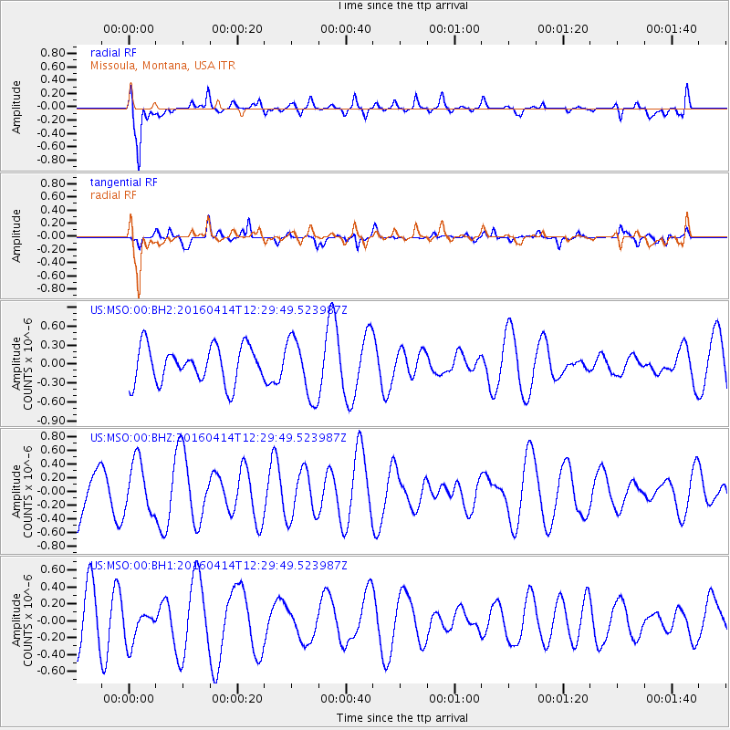
MSO Missoula, Montana, USA - Earthquake Result Viewer
*The percent match for this event was below the threshold and hence no stack was calculated.
| Earthquake location: |
Vanuatu Islands |
| Earthquake latitude/longitude: |
-14.5/166.5 |
| Earthquake time(UTC): |
2016/04/14 (105) 12:17:05 GMT |
| Earthquake Depth: |
10 km |
| Earthquake Magnitude: |
6.0 MO |
| Earthquake Catalog/Contributor: |
NEIC PDE/NEIC ALERT |
|
| Network: |
US United States National Seismic Network |
| Station: |
MSO Missoula, Montana, USA |
| Lat/Lon: |
46.83 N/113.94 W |
| Elevation: |
1264 m |
|
| Distance: |
93.5 deg |
| Az: |
42.573 deg |
| Baz: |
252.619 deg |
| Ray Param: |
$rayparam |
*The percent match for this event was below the threshold and hence was not used in the summary stack. |
|
| Radial Match: |
75.72278 % |
| Radial Bump: |
400 |
| Transverse Match: |
69.86473 % |
| Transverse Bump: |
358 |
| SOD ConfigId: |
7422571 |
| Insert Time: |
2019-04-22 06:08:14.777 +0000 |
| GWidth: |
2.5 |
| Max Bumps: |
400 |
| Tol: |
0.001 |
|
Signal To Noise
| Channel | StoN | STA | LTA |
| US:MSO:00:BHZ:20160414T12:29:49.523987Z | 1.2930167 | 3.790504E-7 | 2.9315197E-7 |
| US:MSO:00:BH1:20160414T12:29:49.523987Z | 0.71172196 | 1.9962357E-7 | 2.804797E-7 |
| US:MSO:00:BH2:20160414T12:29:49.523987Z | 1.530579 | 4.373151E-7 | 2.8571873E-7 |
| Arrivals |
| Ps | |
| PpPs | |
| PsPs/PpSs | |


