You are here: Home > Network List > AG - Arkansas Seismic Network Stations List
> Station LCAR Lake Charles,AR > Earthquake Result Viewer
LCAR Lake Charles,AR - Earthquake Result Viewer
| Earthquake location: |
Panama-Colombia Border Region |
| Earthquake latitude/longitude: |
8.2/-77.3 |
| Earthquake time(UTC): |
2015/07/29 (210) 00:10:24 GMT |
| Earthquake Depth: |
10 km |
| Earthquake Magnitude: |
5.9 MWP, 6.1 MI |
| Earthquake Catalog/Contributor: |
NEIC PDE/NEIC COMCAT |
|
| Network: |
AG Arkansas Seismic Network |
| Station: |
LCAR Lake Charles,AR |
| Lat/Lon: |
36.07 N/91.15 W |
| Elevation: |
103 m |
|
| Distance: |
30.5 deg |
| Az: |
337.494 deg |
| Baz: |
152.118 deg |
| Ray Param: |
0.07932749 |
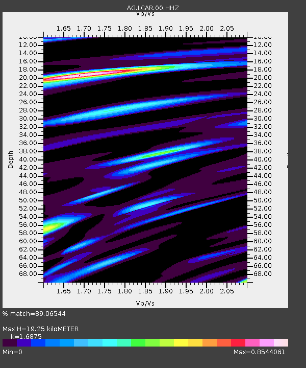
| Estimated Moho Depth: |
19.25 km |
| Estimated Crust Vp/Vs: |
1.69 |
| Assumed Crust Vp: |
6.53 km/s |
| Estimated Crust Vs: |
3.87 km/s |
| Estimated Crust Poisson's Ratio: |
0.23 |
|
| Radial Match: |
89.06544 % |
| Radial Bump: |
278 |
| Transverse Match: |
77.71819 % |
| Transverse Bump: |
400 |
| SOD ConfigId: |
1085051 |
| Insert Time: |
2015-08-12 00:20:15.132 +0000 |
| GWidth: |
2.5 |
| Max Bumps: |
400 |
| Tol: |
0.001 |
|

Signal To Noise
| Channel | StoN | STA | LTA |
| AG:LCAR:00:HHZ:20150729T00:16:06.435013Z | 12.181757 | 8.323023E-7 | 6.8323665E-8 |
| AG:LCAR:00:HHN:20150729T00:16:06.435013Z | 12.238521 | 4.9790043E-7 | 4.068306E-8 |
| AG:LCAR:00:HHE:20150729T00:16:06.435013Z | 6.3890834 | 2.532748E-7 | 3.9641808E-8 |
| Arrivals |
| Ps | 2.2 SECOND |
| PpPs | 7.3 SECOND |
| PsPs/PpSs | 9.5 SECOND |


