You are here: Home > Network List > US - United States National Seismic Network Stations List
> Station AGMN Agassiz National Wildlife Refuge, Minnesota, USA > Earthquake Result Viewer
AGMN Agassiz National Wildlife Refuge, Minnesota, USA - Earthquake Result Viewer
| Earthquake location: |
Peru-Ecuador Border Region |
| Earthquake latitude/longitude: |
-2.3/-77.8 |
| Earthquake time(UTC): |
2007/11/16 (320) 03:13:00 GMT |
| Earthquake Depth: |
123 km |
| Earthquake Magnitude: |
6.3 MB, 6.8 MW, 6.7 MW |
| Earthquake Catalog/Contributor: |
WHDF/NEIC |
|
| Network: |
US United States National Seismic Network |
| Station: |
AGMN Agassiz National Wildlife Refuge, Minnesota, USA |
| Lat/Lon: |
48.30 N/95.86 W |
| Elevation: |
351 m |
|
| Distance: |
52.8 deg |
| Az: |
344.966 deg |
| Baz: |
157.16 deg |
| Ray Param: |
0.066118084 |
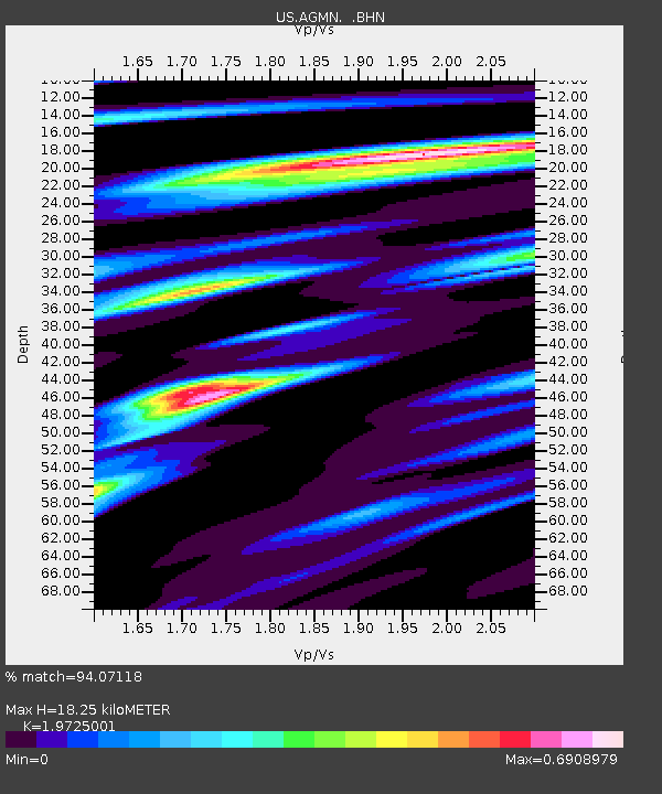
| Estimated Moho Depth: |
18.25 km |
| Estimated Crust Vp/Vs: |
1.97 |
| Assumed Crust Vp: |
6.419 km/s |
| Estimated Crust Vs: |
3.254 km/s |
| Estimated Crust Poisson's Ratio: |
0.33 |
|
| Radial Match: |
94.07118 % |
| Radial Bump: |
280 |
| Transverse Match: |
66.754036 % |
| Transverse Bump: |
400 |
| SOD ConfigId: |
2564 |
| Insert Time: |
2010-03-05 01:22:32.143 +0000 |
| GWidth: |
2.5 |
| Max Bumps: |
400 |
| Tol: |
0.001 |
|

Signal To Noise
| Channel | StoN | STA | LTA |
| US:AGMN: :BHN:20071116T03:21:32.150029Z | 23.93313 | 3.6794095E-6 | 1.5373708E-7 |
| US:AGMN: :BHE:20071116T03:21:32.150029Z | 7.922929 | 2.5029499E-6 | 3.1591222E-7 |
| US:AGMN: :BHZ:20071116T03:21:32.150029Z | 13.456257 | 4.0173363E-6 | 2.9854783E-7 |
| Arrivals |
| Ps | 2.9 SECOND |
| PpPs | 8.1 SECOND |
| PsPs/PpSs | 11 SECOND |


