You are here: Home > Network List > US - United States National Seismic Network Stations List
> Station AGMN Agassiz National Wildlife Refuge, Minnesota, USA > Earthquake Result Viewer
AGMN Agassiz National Wildlife Refuge, Minnesota, USA - Earthquake Result Viewer
| Earthquake location: |
Northern Colombia |
| Earthquake latitude/longitude: |
7.2/-72.1 |
| Earthquake time(UTC): |
2007/07/16 (197) 22:58:23 GMT |
| Earthquake Depth: |
30 km |
| Earthquake Magnitude: |
5.5 MB, 4.5 MS, 5.1 MW, 5.6 ML |
| Earthquake Catalog/Contributor: |
WHDF/NEIC |
|
| Network: |
US United States National Seismic Network |
| Station: |
AGMN Agassiz National Wildlife Refuge, Minnesota, USA |
| Lat/Lon: |
48.30 N/95.86 W |
| Elevation: |
351 m |
|
| Distance: |
45.7 deg |
| Az: |
337.923 deg |
| Baz: |
146.048 deg |
| Ray Param: |
0.071078524 |
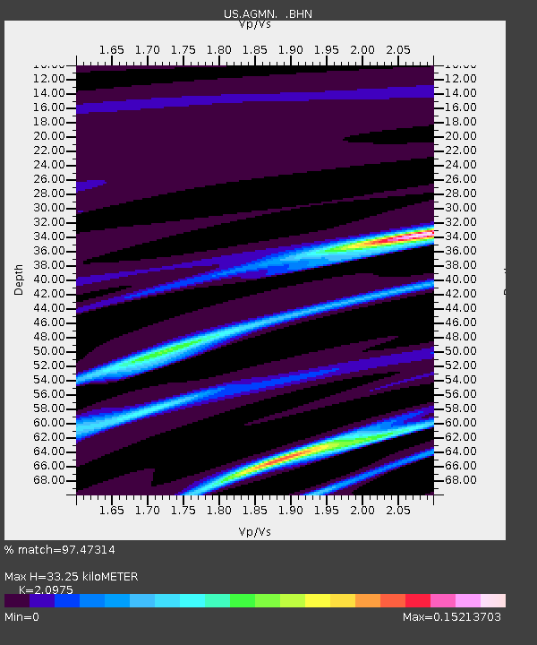
| Estimated Moho Depth: |
33.25 km |
| Estimated Crust Vp/Vs: |
2.10 |
| Assumed Crust Vp: |
6.419 km/s |
| Estimated Crust Vs: |
3.06 km/s |
| Estimated Crust Poisson's Ratio: |
0.35 |
|
| Radial Match: |
97.47314 % |
| Radial Bump: |
134 |
| Transverse Match: |
22.842796 % |
| Transverse Bump: |
339 |
| SOD ConfigId: |
2564 |
| Insert Time: |
2010-03-05 01:23:03.746 +0000 |
| GWidth: |
2.5 |
| Max Bumps: |
400 |
| Tol: |
0.001 |
|
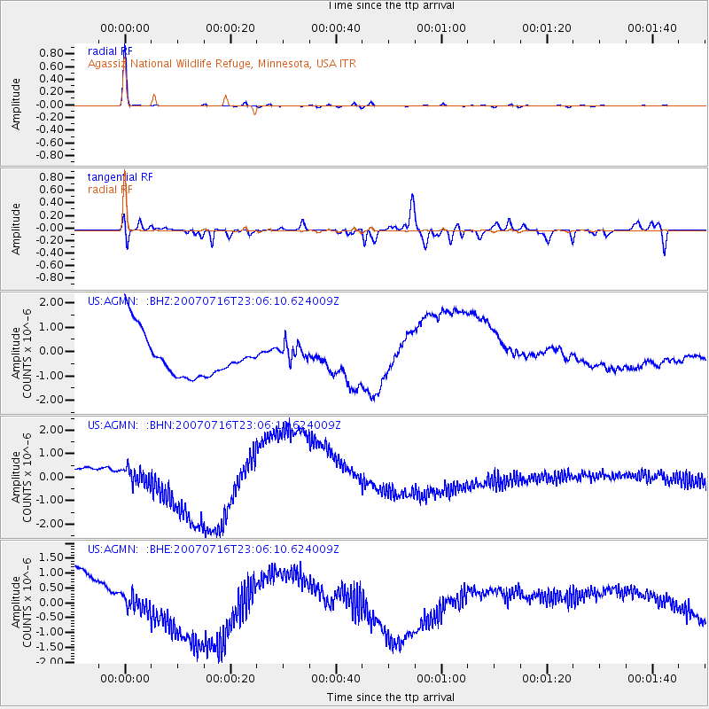
Signal To Noise
| Channel | StoN | STA | LTA |
| US:AGMN: :BHN:20070716T23:06:10.624009Z | 0.8198411 | 4.5402405E-7 | 5.537952E-7 |
| US:AGMN: :BHE:20070716T23:06:10.624009Z | 0.13614583 | 2.7446245E-7 | 2.0159446E-6 |
| US:AGMN: :BHZ:20070716T23:06:10.624009Z | 0.5075631 | 4.3925291E-7 | 8.6541536E-7 |
| Arrivals |
| Ps | 6.0 SECOND |
| PpPs | 15 SECOND |
| PsPs/PpSs | 21 SECOND |


