You are here: Home > Network List > GS - US Geological Survey Networks Stations List
> Station DEC12 Decatur Surface Seismic Site, Decatur, IL, USA > Earthquake Result Viewer
DEC12 Decatur Surface Seismic Site, Decatur, IL, USA - Earthquake Result Viewer
| Earthquake location: |
Panama-Colombia Border Region |
| Earthquake latitude/longitude: |
8.2/-77.3 |
| Earthquake time(UTC): |
2015/07/29 (210) 00:10:24 GMT |
| Earthquake Depth: |
10 km |
| Earthquake Magnitude: |
5.9 MWP, 6.1 MI |
| Earthquake Catalog/Contributor: |
NEIC PDE/NEIC COMCAT |
|
| Network: |
GS US Geological Survey Networks |
| Station: |
DEC12 Decatur Surface Seismic Site, Decatur, IL, USA |
| Lat/Lon: |
39.91 N/88.91 W |
| Elevation: |
208 m |
|
| Distance: |
33.2 deg |
| Az: |
343.581 deg |
| Baz: |
158.671 deg |
| Ray Param: |
0.07831633 |
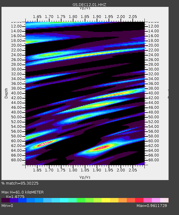
| Estimated Moho Depth: |
61.0 km |
| Estimated Crust Vp/Vs: |
1.68 |
| Assumed Crust Vp: |
6.444 km/s |
| Estimated Crust Vs: |
3.841 km/s |
| Estimated Crust Poisson's Ratio: |
0.22 |
|
| Radial Match: |
85.30225 % |
| Radial Bump: |
400 |
| Transverse Match: |
80.44784 % |
| Transverse Bump: |
400 |
| SOD ConfigId: |
1085051 |
| Insert Time: |
2015-08-12 00:21:51.043 +0000 |
| GWidth: |
2.5 |
| Max Bumps: |
400 |
| Tol: |
0.001 |
|

Signal To Noise
| Channel | StoN | STA | LTA |
| GS:DEC12:01:HHZ:20150729T00:16:30.515Z | 4.758079 | 9.2024044E-7 | 1.9340588E-7 |
| GS:DEC12:01:HHN:20150729T00:16:30.515Z | 1.9488627 | 6.2819635E-7 | 3.2234E-7 |
| GS:DEC12:01:HHE:20150729T00:16:30.515Z | 1.0956162 | 4.1130625E-7 | 3.7541085E-7 |
| Arrivals |
| Ps | 7.0 SECOND |
| PpPs | 23 SECOND |
| PsPs/PpSs | 30 SECOND |


