You are here: Home > Network List > AV - Alaska Volcano Observatory Stations List
> Station SPCR Ckakachatna River, Mount Spurr, Alaska > Earthquake Result Viewer
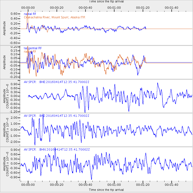
SPCR Ckakachatna River, Mount Spurr, Alaska - Earthquake Result Viewer
*The percent match for this event was below the threshold and hence no stack was calculated.
| Earthquake location: |
Kyushu, Japan |
| Earthquake latitude/longitude: |
32.8/130.6 |
| Earthquake time(UTC): |
2016/04/14 (105) 12:26:36 GMT |
| Earthquake Depth: |
10 km |
| Earthquake Magnitude: |
6.2 MWW |
| Earthquake Catalog/Contributor: |
NEIC PDE/NEIC COMCAT |
|
| Network: |
AV Alaska Volcano Observatory |
| Station: |
SPCR Ckakachatna River, Mount Spurr, Alaska |
| Lat/Lon: |
61.20 N/152.21 W |
| Elevation: |
984 m |
|
| Distance: |
55.7 deg |
| Az: |
34.837 deg |
| Baz: |
276.789 deg |
| Ray Param: |
$rayparam |
*The percent match for this event was below the threshold and hence was not used in the summary stack. |
|
| Radial Match: |
58.63296 % |
| Radial Bump: |
400 |
| Transverse Match: |
38.54791 % |
| Transverse Bump: |
360 |
| SOD ConfigId: |
7422571 |
| Insert Time: |
2019-04-22 06:12:20.499 +0000 |
| GWidth: |
2.5 |
| Max Bumps: |
400 |
| Tol: |
0.001 |
|
Signal To Noise
| Channel | StoN | STA | LTA |
| AV:SPCR: :BHZ:20160414T12:35:41.70002Z | 5.218556 | 1.08069E-6 | 2.0708603E-7 |
| AV:SPCR: :BHN:20160414T12:35:41.70002Z | 1.429221 | 4.1534122E-7 | 2.9060672E-7 |
| AV:SPCR: :BHE:20160414T12:35:41.70002Z | 1.5344472 | 1.8717634E-7 | 1.2198291E-7 |
| Arrivals |
| Ps | |
| PpPs | |
| PsPs/PpSs | |


