You are here: Home > Network List > CN - Canadian National Seismograph Network Stations List
> Station INK INUVIK, NT > Earthquake Result Viewer
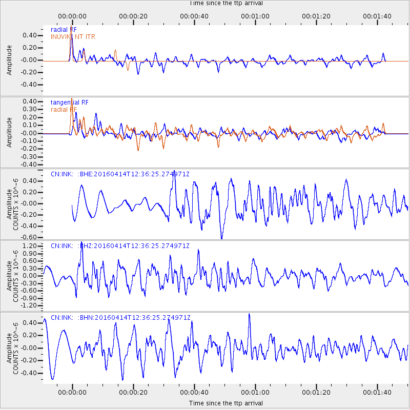
INK INUVIK, NT - Earthquake Result Viewer
*The percent match for this event was below the threshold and hence no stack was calculated.
| Earthquake location: |
Kyushu, Japan |
| Earthquake latitude/longitude: |
32.8/130.6 |
| Earthquake time(UTC): |
2016/04/14 (105) 12:26:36 GMT |
| Earthquake Depth: |
10 km |
| Earthquake Magnitude: |
6.2 MWW |
| Earthquake Catalog/Contributor: |
NEIC PDE/NEIC COMCAT |
|
| Network: |
CN Canadian National Seismograph Network |
| Station: |
INK INUVIK, NT |
| Lat/Lon: |
68.31 N/133.53 W |
| Elevation: |
44 m |
|
| Distance: |
62.0 deg |
| Az: |
24.762 deg |
| Baz: |
288.503 deg |
| Ray Param: |
$rayparam |
*The percent match for this event was below the threshold and hence was not used in the summary stack. |
|
| Radial Match: |
63.917477 % |
| Radial Bump: |
400 |
| Transverse Match: |
57.697906 % |
| Transverse Bump: |
400 |
| SOD ConfigId: |
7422571 |
| Insert Time: |
2019-04-22 06:13:25.624 +0000 |
| GWidth: |
2.5 |
| Max Bumps: |
400 |
| Tol: |
0.001 |
|
Signal To Noise
| Channel | StoN | STA | LTA |
| CN:INK: :BHZ:20160414T12:36:25.274971Z | 2.6816413 | 5.311415E-7 | 1.9806582E-7 |
| CN:INK: :BHN:20160414T12:36:25.274971Z | 0.51616096 | 9.811913E-8 | 1.9009406E-7 |
| CN:INK: :BHE:20160414T12:36:25.274971Z | 1.9401631 | 2.7029168E-7 | 1.393139E-7 |
| Arrivals |
| Ps | |
| PpPs | |
| PsPs/PpSs | |


