You are here: Home > Network List > US - United States National Seismic Network Stations List
> Station AGMN Agassiz National Wildlife Refuge, Minnesota, USA > Earthquake Result Viewer
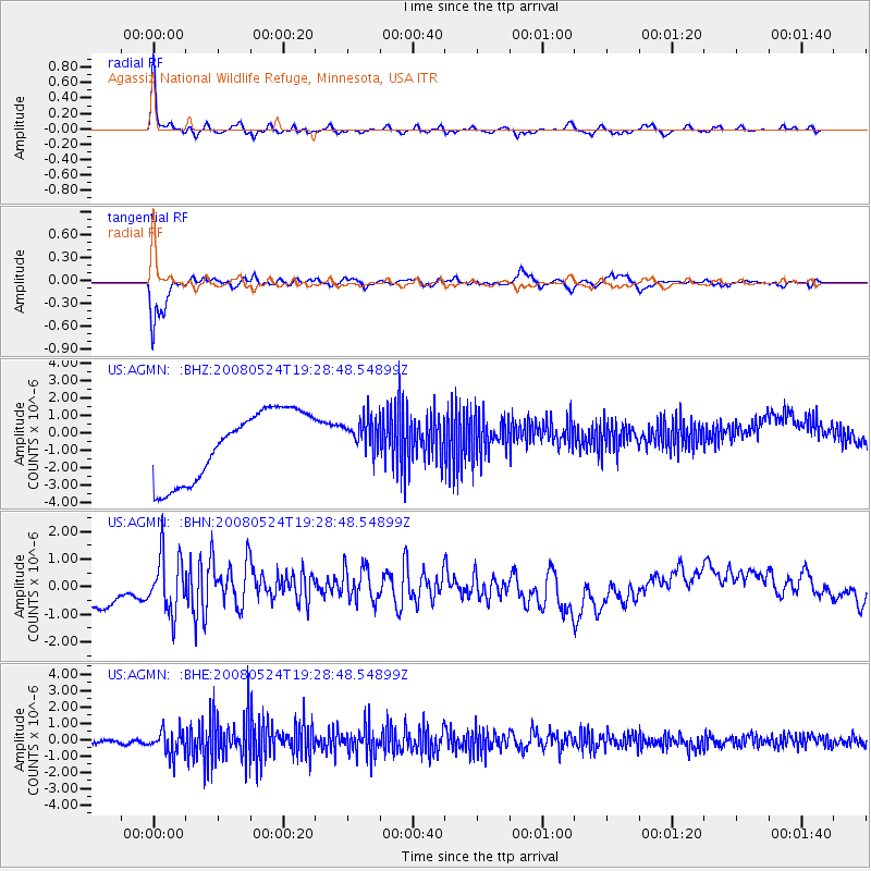
AGMN Agassiz National Wildlife Refuge, Minnesota, USA - Earthquake Result Viewer

| Earthquake location: |
Colombia |
| Earthquake latitude/longitude: |
4.3/-73.8 |
| Earthquake time(UTC): |
2008/05/24 (145) 19:20:42 GMT |
| Earthquake Depth: |
8.9 km |
| Earthquake Magnitude: |
5.6 MB, 5.6 MS, 5.9 MW, 5.9 MW |
| Earthquake Catalog/Contributor: |
WHDF/NEIC |
|
| Network: |
US United States National Seismic Network |
| Station: |
AGMN Agassiz National Wildlife Refuge, Minnesota, USA |
| Lat/Lon: |
48.30 N/95.86 W |
| Elevation: |
351 m |
|
| Distance: |
47.7 deg |
| Az: |
340.152 deg |
| Baz: |
149.533 deg |
| Ray Param: |
0.06981439 |
| Estimated Moho Depth: |
20.75 km |
| Estimated Crust Vp/Vs: |
1.74 |
| Assumed Crust Vp: |
6.419 km/s |
| Estimated Crust Vs: |
3.689 km/s |
| Estimated Crust Poisson's Ratio: |
0.25 |
|
| Radial Match: |
93.48098 % |
| Radial Bump: |
293 |
| Transverse Match: |
92.67965 % |
| Transverse Bump: |
287 |
| SOD ConfigId: |
2504 |
| Insert Time: |
2010-03-05 01:23:27.374 +0000 |
| GWidth: |
2.5 |
| Max Bumps: |
400 |
| Tol: |
0.001 |
|
Signal To Noise
| Channel | StoN | STA | LTA |
| US:AGMN: :BHN:20080524T19:28:48.54899Z | 0.94139713 | 1.0419938E-6 | 1.1068589E-6 |
| US:AGMN: :BHE:20080524T19:28:48.54899Z | 6.5160527 | 7.59069E-7 | 1.1649215E-7 |
| US:AGMN: :BHZ:20080524T19:28:48.54899Z | 0.5330073 | 1.0622657E-6 | 1.9929664E-6 |
| Arrivals |
| Ps | 2.5 SECOND |
| PpPs | 8.3 SECOND |
| PsPs/PpSs | 11 SECOND |


