You are here: Home > Network List > GS - US Geological Survey Networks Stations List
> Station KAN13 Rinehart Farm, , CA, USA > Earthquake Result Viewer
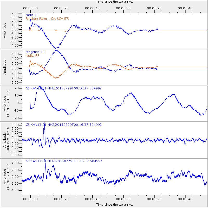
KAN13 Rinehart Farm, , CA, USA - Earthquake Result Viewer
*The percent match for this event was below the threshold and hence no stack was calculated.
| Earthquake location: |
Panama-Colombia Border Region |
| Earthquake latitude/longitude: |
8.2/-77.3 |
| Earthquake time(UTC): |
2015/07/29 (210) 00:10:24 GMT |
| Earthquake Depth: |
10 km |
| Earthquake Magnitude: |
5.9 MWP, 6.1 MI |
| Earthquake Catalog/Contributor: |
NEIC PDE/NEIC COMCAT |
|
| Network: |
GS US Geological Survey Networks |
| Station: |
KAN13 Rinehart Farm, , CA, USA |
| Lat/Lon: |
37.01 N/97.48 W |
| Elevation: |
340 m |
|
| Distance: |
34.0 deg |
| Az: |
330.416 deg |
| Baz: |
142.374 deg |
| Ray Param: |
$rayparam |
*The percent match for this event was below the threshold and hence was not used in the summary stack. |
|
| Radial Match: |
41.73382 % |
| Radial Bump: |
400 |
| Transverse Match: |
42.36126 % |
| Transverse Bump: |
400 |
| SOD ConfigId: |
1085051 |
| Insert Time: |
2015-08-12 00:22:33.908 +0000 |
| GWidth: |
2.5 |
| Max Bumps: |
400 |
| Tol: |
0.001 |
|
Signal To Noise
| Channel | StoN | STA | LTA |
| GS:KAN13:01:HHZ:20150729T00:16:37.50499Z | 2.5898569 | 9.0353467E-7 | 3.4887435E-7 |
| GS:KAN13:01:HHN:20150729T00:16:37.50499Z | 0.5263449 | 5.997724E-7 | 1.1395047E-6 |
| GS:KAN13:01:HHE:20150729T00:16:37.50499Z | 0.5050613 | 5.9040312E-6 | 1.1689732E-5 |
| Arrivals |
| Ps | |
| PpPs | |
| PsPs/PpSs | |


