You are here: Home > Network List > TA - USArray Transportable Network (new EarthScope stations) Stations List
> Station BGNE Belgrade, NE, USA > Earthquake Result Viewer
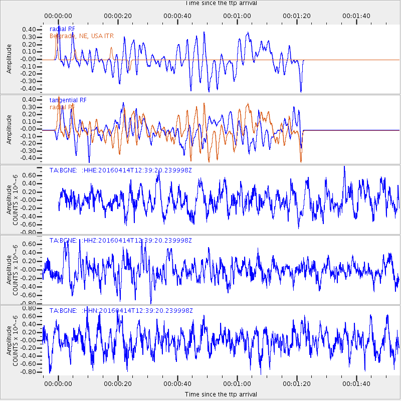
BGNE Belgrade, NE, USA - Earthquake Result Viewer
*The percent match for this event was below the threshold and hence no stack was calculated.
| Earthquake location: |
Kyushu, Japan |
| Earthquake latitude/longitude: |
32.8/130.6 |
| Earthquake time(UTC): |
2016/04/14 (105) 12:26:36 GMT |
| Earthquake Depth: |
10 km |
| Earthquake Magnitude: |
6.2 MWW |
| Earthquake Catalog/Contributor: |
NEIC PDE/NEIC COMCAT |
|
| Network: |
TA USArray Transportable Network (new EarthScope stations) |
| Station: |
BGNE Belgrade, NE, USA |
| Lat/Lon: |
41.41 N/98.15 W |
| Elevation: |
573 m |
|
| Distance: |
93.5 deg |
| Az: |
34.536 deg |
| Baz: |
320.625 deg |
| Ray Param: |
$rayparam |
*The percent match for this event was below the threshold and hence was not used in the summary stack. |
|
| Radial Match: |
63.445248 % |
| Radial Bump: |
400 |
| Transverse Match: |
56.92976 % |
| Transverse Bump: |
400 |
| SOD ConfigId: |
7422571 |
| Insert Time: |
2019-04-22 06:16:49.393 +0000 |
| GWidth: |
2.5 |
| Max Bumps: |
400 |
| Tol: |
0.001 |
|
Signal To Noise
| Channel | StoN | STA | LTA |
| TA:BGNE: :HHZ:20160414T12:39:20.239998Z | 2.4862678 | 3.6973603E-7 | 1.4871127E-7 |
| TA:BGNE: :HHN:20160414T12:39:20.239998Z | 0.80426484 | 2.3898332E-7 | 2.9714508E-7 |
| TA:BGNE: :HHE:20160414T12:39:20.239998Z | 1.807822 | 3.2308932E-7 | 1.7871746E-7 |
| Arrivals |
| Ps | |
| PpPs | |
| PsPs/PpSs | |


