You are here: Home > Network List > TA - USArray Transportable Network (new EarthScope stations) Stations List
> Station L20K Farewell, AK, USA > Earthquake Result Viewer
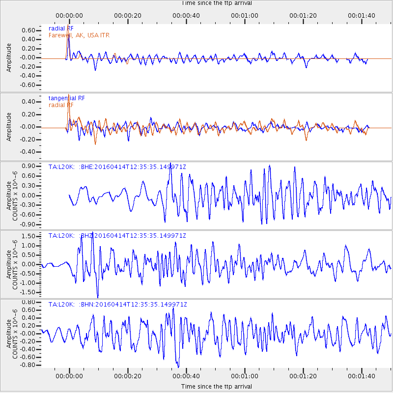
L20K Farewell, AK, USA - Earthquake Result Viewer
*The percent match for this event was below the threshold and hence no stack was calculated.
| Earthquake location: |
Kyushu, Japan |
| Earthquake latitude/longitude: |
32.8/130.6 |
| Earthquake time(UTC): |
2016/04/14 (105) 12:26:36 GMT |
| Earthquake Depth: |
10 km |
| Earthquake Magnitude: |
6.2 MWW |
| Earthquake Catalog/Contributor: |
NEIC PDE/NEIC COMCAT |
|
| Network: |
TA USArray Transportable Network (new EarthScope stations) |
| Station: |
L20K Farewell, AK, USA |
| Lat/Lon: |
62.48 N/153.88 W |
| Elevation: |
673 m |
|
| Distance: |
54.8 deg |
| Az: |
33.378 deg |
| Baz: |
274.488 deg |
| Ray Param: |
$rayparam |
*The percent match for this event was below the threshold and hence was not used in the summary stack. |
|
| Radial Match: |
66.554016 % |
| Radial Bump: |
400 |
| Transverse Match: |
67.05718 % |
| Transverse Bump: |
400 |
| SOD ConfigId: |
7422571 |
| Insert Time: |
2019-04-22 06:17:06.247 +0000 |
| GWidth: |
2.5 |
| Max Bumps: |
400 |
| Tol: |
0.001 |
|
Signal To Noise
| Channel | StoN | STA | LTA |
| TA:L20K: :BHZ:20160414T12:35:35.149971Z | 4.077192 | 6.7170964E-7 | 1.6474812E-7 |
| TA:L20K: :BHN:20160414T12:35:35.149971Z | 1.0561947 | 1.5989042E-7 | 1.5138349E-7 |
| TA:L20K: :BHE:20160414T12:35:35.149971Z | 2.4334571 | 4.5283502E-7 | 1.860871E-7 |
| Arrivals |
| Ps | |
| PpPs | |
| PsPs/PpSs | |


