You are here: Home > Network List > TA - USArray Transportable Network (new EarthScope stations) Stations List
> Station O03E Paynes Creek, CA, USA > Earthquake Result Viewer
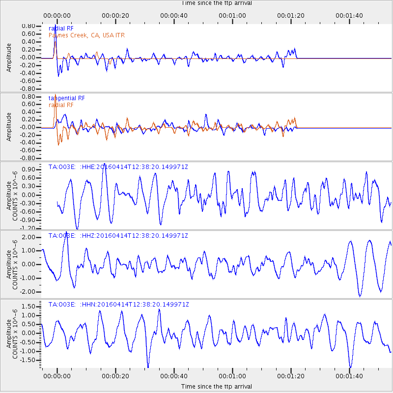
O03E Paynes Creek, CA, USA - Earthquake Result Viewer
*The percent match for this event was below the threshold and hence no stack was calculated.
| Earthquake location: |
Kyushu, Japan |
| Earthquake latitude/longitude: |
32.8/130.6 |
| Earthquake time(UTC): |
2016/04/14 (105) 12:26:36 GMT |
| Earthquake Depth: |
10 km |
| Earthquake Magnitude: |
6.2 MWW |
| Earthquake Catalog/Contributor: |
NEIC PDE/NEIC COMCAT |
|
| Network: |
TA USArray Transportable Network (new EarthScope stations) |
| Station: |
O03E Paynes Creek, CA, USA |
| Lat/Lon: |
40.29 N/121.80 W |
| Elevation: |
967 m |
|
| Distance: |
81.2 deg |
| Az: |
47.558 deg |
| Baz: |
305.695 deg |
| Ray Param: |
$rayparam |
*The percent match for this event was below the threshold and hence was not used in the summary stack. |
|
| Radial Match: |
64.40089 % |
| Radial Bump: |
400 |
| Transverse Match: |
72.63742 % |
| Transverse Bump: |
400 |
| SOD ConfigId: |
7422571 |
| Insert Time: |
2019-04-22 06:17:17.397 +0000 |
| GWidth: |
2.5 |
| Max Bumps: |
400 |
| Tol: |
0.001 |
|
Signal To Noise
| Channel | StoN | STA | LTA |
| TA:O03E: :HHZ:20160414T12:38:20.149971Z | 1.6759353 | 1.2493546E-6 | 7.454671E-7 |
| TA:O03E: :HHN:20160414T12:38:20.149971Z | 0.9375796 | 5.13964E-7 | 5.481817E-7 |
| TA:O03E: :HHE:20160414T12:38:20.149971Z | 1.0079852 | 5.3179104E-7 | 5.2757815E-7 |
| Arrivals |
| Ps | |
| PpPs | |
| PsPs/PpSs | |


