You are here: Home > Network List > TA - USArray Transportable Network (new EarthScope stations) Stations List
> Station TCOL CIGO, UAF Yankovich Road, Fairbanks, AK, USA > Earthquake Result Viewer
TCOL CIGO, UAF Yankovich Road, Fairbanks, AK, USA - Earthquake Result Viewer
| Earthquake location: |
Kyushu, Japan |
| Earthquake latitude/longitude: |
32.8/130.6 |
| Earthquake time(UTC): |
2016/04/14 (105) 12:26:36 GMT |
| Earthquake Depth: |
10 km |
| Earthquake Magnitude: |
6.2 MWW |
| Earthquake Catalog/Contributor: |
NEIC PDE/NEIC COMCAT |
|
| Network: |
TA USArray Transportable Network (new EarthScope stations) |
| Station: |
TCOL CIGO, UAF Yankovich Road, Fairbanks, AK, USA |
| Lat/Lon: |
64.87 N/147.86 W |
| Elevation: |
178 m |
|
| Distance: |
57.2 deg |
| Az: |
30.146 deg |
| Baz: |
278.07 deg |
| Ray Param: |
0.063623756 |
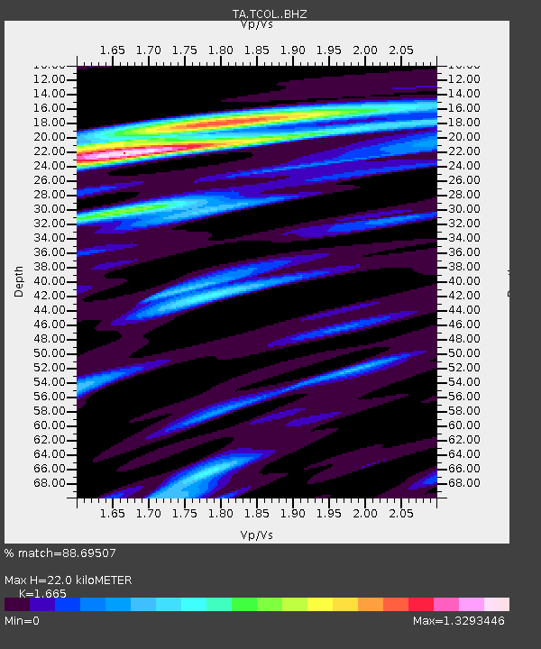
| Estimated Moho Depth: |
22.0 km |
| Estimated Crust Vp/Vs: |
1.66 |
| Assumed Crust Vp: |
6.566 km/s |
| Estimated Crust Vs: |
3.944 km/s |
| Estimated Crust Poisson's Ratio: |
0.22 |
|
| Radial Match: |
88.69507 % |
| Radial Bump: |
400 |
| Transverse Match: |
61.425617 % |
| Transverse Bump: |
400 |
| SOD ConfigId: |
7422571 |
| Insert Time: |
2019-04-22 06:17:25.075 +0000 |
| GWidth: |
2.5 |
| Max Bumps: |
400 |
| Tol: |
0.001 |
|

Signal To Noise
| Channel | StoN | STA | LTA |
| TA:TCOL: :BHZ:20160414T12:35:52.349983Z | 3.7807026 | 8.340566E-7 | 2.206089E-7 |
| TA:TCOL: :BHN:20160414T12:35:52.349983Z | 1.5742191 | 2.661704E-7 | 1.690809E-7 |
| TA:TCOL: :BHE:20160414T12:35:52.349983Z | 3.0271308 | 3.6829746E-7 | 1.2166552E-7 |
| Arrivals |
| Ps | 2.4 SECOND |
| PpPs | 8.4 SECOND |
| PsPs/PpSs | 11 SECOND |


