You are here: Home > Network List > CI - Caltech Regional Seismic Network Stations List
> Station BAR Barrett, Tecate, CA, USA > Earthquake Result Viewer
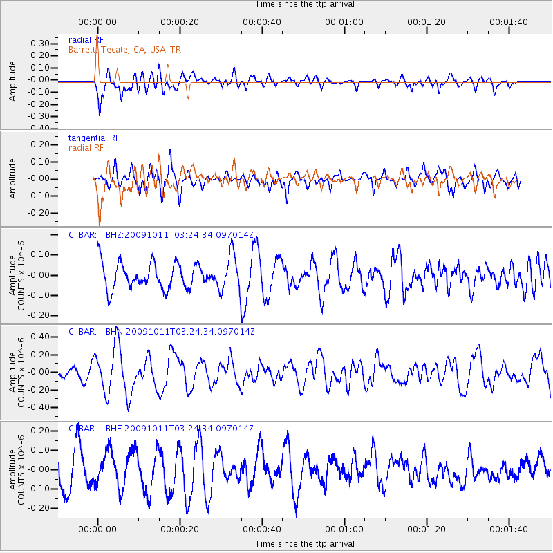
BAR Barrett, Tecate, CA, USA - Earthquake Result Viewer
*The percent match for this event was below the threshold and hence no stack was calculated.
| Earthquake location: |
Southeast Of Loyalty Islands |
| Earthquake latitude/longitude: |
-22.0/170.2 |
| Earthquake time(UTC): |
2009/10/11 (284) 03:12:13 GMT |
| Earthquake Depth: |
10 km |
| Earthquake Magnitude: |
5.7 MB, 5.5 MS, 6.0 MW, 5.9 MW |
| Earthquake Catalog/Contributor: |
WHDF/NEIC |
|
| Network: |
CI Caltech Regional Seismic Network |
| Station: |
BAR Barrett, Tecate, CA, USA |
| Lat/Lon: |
32.68 N/116.67 W |
| Elevation: |
521 m |
|
| Distance: |
88.4 deg |
| Az: |
53.818 deg |
| Baz: |
242.65 deg |
| Ray Param: |
$rayparam |
*The percent match for this event was below the threshold and hence was not used in the summary stack. |
|
| Radial Match: |
66.86911 % |
| Radial Bump: |
400 |
| Transverse Match: |
50.21168 % |
| Transverse Bump: |
359 |
| SOD ConfigId: |
2622 |
| Insert Time: |
2010-02-26 00:14:04.606 +0000 |
| GWidth: |
2.5 |
| Max Bumps: |
400 |
| Tol: |
0.001 |
|
Signal To Noise
| Channel | StoN | STA | LTA |
| CI:BAR: :BHN:20091011T03:24:34.097014Z | 2.508234 | 2.5910026E-7 | 1.0329988E-7 |
| CI:BAR: :BHE:20091011T03:24:34.097014Z | 0.5967273 | 7.5718184E-8 | 1.2688908E-7 |
| CI:BAR: :BHZ:20091011T03:24:34.097014Z | 1.4311411 | 9.412193E-8 | 6.5767054E-8 |
| Arrivals |
| Ps | |
| PpPs | |
| PsPs/PpSs | |


