You are here: Home > Network List > N4 - Central and EAstern US Network Stations List
> Station I49A Point Hope, MI, USA > Earthquake Result Viewer
I49A Point Hope, MI, USA - Earthquake Result Viewer
| Earthquake location: |
Kyushu, Japan |
| Earthquake latitude/longitude: |
32.7/130.8 |
| Earthquake time(UTC): |
2016/04/14 (105) 13:07:35 GMT |
| Earthquake Depth: |
10 km |
| Earthquake Magnitude: |
5.4 Mww |
| Earthquake Catalog/Contributor: |
NEIC PDE/us |
|
| Network: |
N4 Central and EAstern US Network |
| Station: |
I49A Point Hope, MI, USA |
| Lat/Lon: |
43.94 N/82.82 W |
| Elevation: |
217 m |
|
| Distance: |
97.7 deg |
| Az: |
23.825 deg |
| Baz: |
331.885 deg |
| Ray Param: |
0.04012504 |
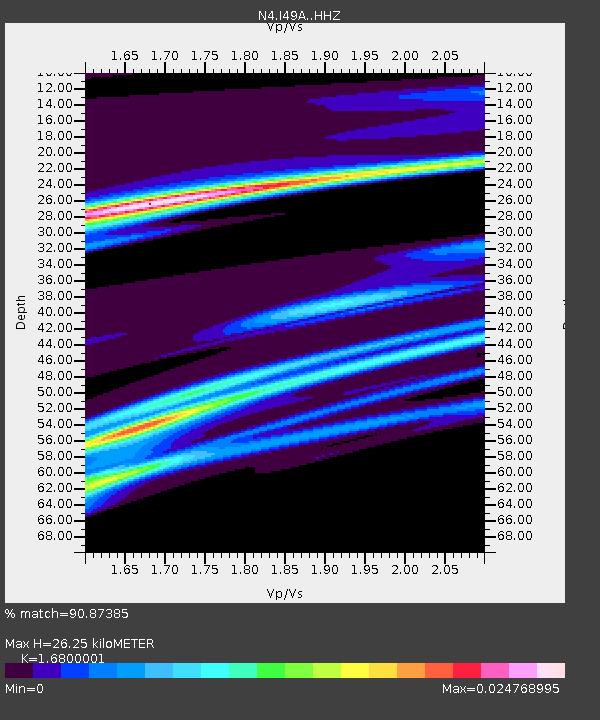
| Estimated Moho Depth: |
26.25 km |
| Estimated Crust Vp/Vs: |
1.68 |
| Assumed Crust Vp: |
6.483 km/s |
| Estimated Crust Vs: |
3.859 km/s |
| Estimated Crust Poisson's Ratio: |
0.23 |
|
| Radial Match: |
90.87385 % |
| Radial Bump: |
361 |
| Transverse Match: |
19.835192 % |
| Transverse Bump: |
400 |
| SOD ConfigId: |
7422571 |
| Insert Time: |
2019-04-22 06:24:16.675 +0000 |
| GWidth: |
2.5 |
| Max Bumps: |
400 |
| Tol: |
0.001 |
|

Signal To Noise
| Channel | StoN | STA | LTA |
| N4:I49A: :HHZ:20160414T13:20:38.779978Z | 1.8024491 | 1.4577444E-4 | 8.0875754E-5 |
| N4:I49A: :HHN:20160414T13:20:38.779978Z | 3.4827297 | 3.9755932E-6 | 1.1415163E-6 |
| N4:I49A: :HHE:20160414T13:20:38.779978Z | 2.7482526 | 2.3779169E-6 | 8.652469E-7 |
| Arrivals |
| Ps | 2.8 SECOND |
| PpPs | 11 SECOND |
| PsPs/PpSs | 13 SECOND |


