You are here: Home > Network List > US - United States National Seismic Network Stations List
> Station AGMN Agassiz National Wildlife Refuge, Minnesota, USA > Earthquake Result Viewer
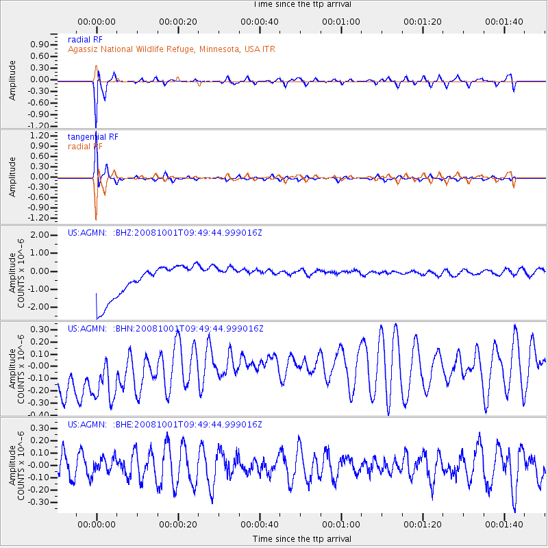
AGMN Agassiz National Wildlife Refuge, Minnesota, USA - Earthquake Result Viewer
*The percent match for this event was below the threshold and hence no stack was calculated.
| Earthquake location: |
Southeast Of Honshu, Japan |
| Earthquake latitude/longitude: |
30.2/138.8 |
| Earthquake time(UTC): |
2008/10/01 (275) 09:38:12 GMT |
| Earthquake Depth: |
414 km |
| Earthquake Magnitude: |
5.7 MW, 5.1 MB, 5.7 MW |
| Earthquake Catalog/Contributor: |
WHDF/NEIC |
|
| Network: |
US United States National Seismic Network |
| Station: |
AGMN Agassiz National Wildlife Refuge, Minnesota, USA |
| Lat/Lon: |
48.30 N/95.86 W |
| Elevation: |
351 m |
|
| Distance: |
87.8 deg |
| Az: |
33.022 deg |
| Baz: |
315.025 deg |
| Ray Param: |
$rayparam |
*The percent match for this event was below the threshold and hence was not used in the summary stack. |
|
| Radial Match: |
88.372406 % |
| Radial Bump: |
388 |
| Transverse Match: |
91.8461 % |
| Transverse Bump: |
295 |
| SOD ConfigId: |
2556 |
| Insert Time: |
2010-03-05 01:25:20.824 +0000 |
| GWidth: |
2.5 |
| Max Bumps: |
400 |
| Tol: |
0.001 |
|
Signal To Noise
| Channel | StoN | STA | LTA |
| US:AGMN: :BHN:20081001T09:49:44.999016Z | 0.88523823 | 5.302714E-7 | 5.990155E-7 |
| US:AGMN: :BHE:20081001T09:49:44.999016Z | 0.5762959 | 6.103604E-8 | 1.0591095E-7 |
| US:AGMN: :BHZ:20081001T09:49:44.999016Z | 0.7400693 | 6.59449E-7 | 8.910638E-7 |
| Arrivals |
| Ps | |
| PpPs | |
| PsPs/PpSs | |


