You are here: Home > Network List > US - United States National Seismic Network Stations List
> Station AGMN Agassiz National Wildlife Refuge, Minnesota, USA > Earthquake Result Viewer
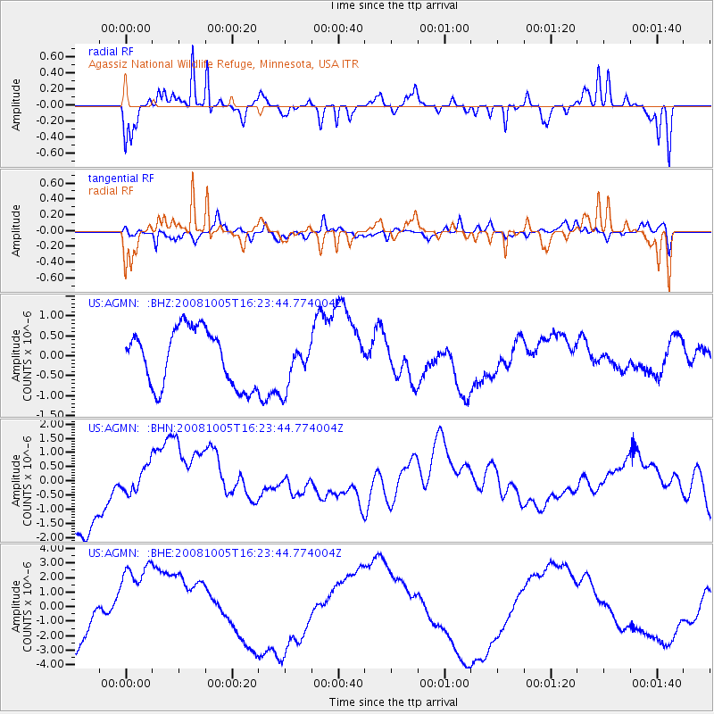
AGMN Agassiz National Wildlife Refuge, Minnesota, USA - Earthquake Result Viewer
*The percent match for this event was below the threshold and hence no stack was calculated.
| Earthquake location: |
Tajikistan-Xinjiang Border Reg. |
| Earthquake latitude/longitude: |
39.5/73.9 |
| Earthquake time(UTC): |
2008/10/05 (279) 16:11:10 GMT |
| Earthquake Depth: |
35 km |
| Earthquake Magnitude: |
5.6 MB |
| Earthquake Catalog/Contributor: |
WHDF/NEIC |
|
| Network: |
US United States National Seismic Network |
| Station: |
AGMN Agassiz National Wildlife Refuge, Minnesota, USA |
| Lat/Lon: |
48.30 N/95.86 W |
| Elevation: |
351 m |
|
| Distance: |
92.1 deg |
| Az: |
353.171 deg |
| Baz: |
7.918 deg |
| Ray Param: |
$rayparam |
*The percent match for this event was below the threshold and hence was not used in the summary stack. |
|
| Radial Match: |
67.66628 % |
| Radial Bump: |
258 |
| Transverse Match: |
54.357388 % |
| Transverse Bump: |
400 |
| SOD ConfigId: |
2556 |
| Insert Time: |
2010-03-05 01:25:22.038 +0000 |
| GWidth: |
2.5 |
| Max Bumps: |
400 |
| Tol: |
0.001 |
|
Signal To Noise
| Channel | StoN | STA | LTA |
| US:AGMN: :BHN:20081005T16:23:44.774004Z | 0.38710484 | 4.7516798E-7 | 1.2274917E-6 |
| US:AGMN: :BHE:20081005T16:23:44.774004Z | 1.9015121 | 3.1321613E-6 | 1.647195E-6 |
| US:AGMN: :BHZ:20081005T16:23:44.774004Z | 0.8149107 | 5.7720496E-7 | 7.083046E-7 |
| Arrivals |
| Ps | |
| PpPs | |
| PsPs/PpSs | |


