You are here: Home > Network List > NM - Cooperative New Madrid Seismic Network Stations List
> Station HENM Henderson Mound,MO > Earthquake Result Viewer
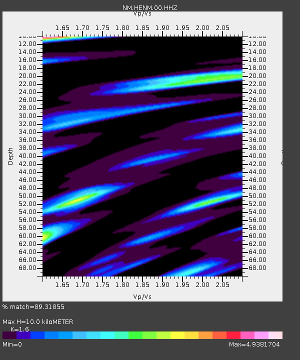
HENM Henderson Mound,MO - Earthquake Result Viewer
| Earthquake location: |
Panama-Colombia Border Region |
| Earthquake latitude/longitude: |
8.2/-77.3 |
| Earthquake time(UTC): |
2015/07/29 (210) 00:10:24 GMT |
| Earthquake Depth: |
10 km |
| Earthquake Magnitude: |
5.9 MWP, 6.1 MI |
| Earthquake Catalog/Contributor: |
NEIC PDE/NEIC COMCAT |
|
| Network: |
NM Cooperative New Madrid Seismic Network |
| Station: |
HENM Henderson Mound,MO |
| Lat/Lon: |
36.72 N/89.47 W |
| Elevation: |
88 m |
|
| Distance: |
30.4 deg |
| Az: |
340.459 deg |
| Baz: |
155.668 deg |
| Ray Param: |
0.0793323 |
| Estimated Moho Depth: |
10.0 km |
| Estimated Crust Vp/Vs: |
1.60 |
| Assumed Crust Vp: |
6.444 km/s |
| Estimated Crust Vs: |
4.027 km/s |
| Estimated Crust Poisson's Ratio: |
0.18 |
|
| Radial Match: |
89.31855 % |
| Radial Bump: |
386 |
| Transverse Match: |
63.96682 % |
| Transverse Bump: |
394 |
| SOD ConfigId: |
1085051 |
| Insert Time: |
2015-08-12 00:26:09.757 +0000 |
| GWidth: |
2.5 |
| Max Bumps: |
400 |
| Tol: |
0.001 |
|

Signal To Noise
| Channel | StoN | STA | LTA |
| NM:HENM:00:HHZ:20150729T00:16:06.280015Z | 3.4074485 | 9.2169716E-7 | 2.704948E-7 |
| NM:HENM:00:HHN:20150729T00:16:06.280015Z | 2.8139117 | 9.5007533E-7 | 3.376351E-7 |
| NM:HENM:00:HHE:20150729T00:16:06.280015Z | 2.2123294 | 8.1225613E-7 | 3.6714974E-7 |
| Arrivals |
| Ps | 1.0 SECOND |
| PpPs | 3.7 SECOND |
| PsPs/PpSs | 4.7 SECOND |


