You are here: Home > Network List > NM - Cooperative New Madrid Seismic Network Stations List
> Station PENM Penman,Portageville,MO > Earthquake Result Viewer
PENM Penman,Portageville,MO - Earthquake Result Viewer
| Earthquake location: |
Panama-Colombia Border Region |
| Earthquake latitude/longitude: |
8.2/-77.3 |
| Earthquake time(UTC): |
2015/07/29 (210) 00:10:24 GMT |
| Earthquake Depth: |
10 km |
| Earthquake Magnitude: |
5.9 MWP, 6.1 MI |
| Earthquake Catalog/Contributor: |
NEIC PDE/NEIC COMCAT |
|
| Network: |
NM Cooperative New Madrid Seismic Network |
| Station: |
PENM Penman,Portageville,MO |
| Lat/Lon: |
36.45 N/89.63 W |
| Elevation: |
85 m |
|
| Distance: |
30.2 deg |
| Az: |
340.015 deg |
| Baz: |
155.192 deg |
| Ray Param: |
0.07938201 |
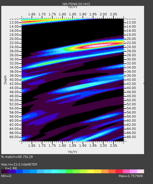
| Estimated Moho Depth: |
23.0 km |
| Estimated Crust Vp/Vs: |
1.98 |
| Assumed Crust Vp: |
6.444 km/s |
| Estimated Crust Vs: |
3.254 km/s |
| Estimated Crust Poisson's Ratio: |
0.33 |
|
| Radial Match: |
89.75129 % |
| Radial Bump: |
337 |
| Transverse Match: |
84.4484 % |
| Transverse Bump: |
313 |
| SOD ConfigId: |
1085051 |
| Insert Time: |
2015-08-12 00:26:26.232 +0000 |
| GWidth: |
2.5 |
| Max Bumps: |
400 |
| Tol: |
0.001 |
|

Signal To Noise
| Channel | StoN | STA | LTA |
| NM:PENM:00:HHZ:20150729T00:16:04.615006Z | 2.6777868 | 1.1787037E-6 | 4.401783E-7 |
| NM:PENM:00:HHN:20150729T00:16:04.615006Z | 2.492605 | 1.2382837E-6 | 4.9678295E-7 |
| NM:PENM:00:HHE:20150729T00:16:04.615006Z | 1.415859 | 9.156045E-7 | 6.466778E-7 |
| Arrivals |
| Ps | 3.8 SECOND |
| PpPs | 9.9 SECOND |
| PsPs/PpSs | 14 SECOND |


