You are here: Home > Network List > UW - Pacific Northwest Regional Seismic Network Stations List
> Station UMAT Pilot Rock, OR, USA > Earthquake Result Viewer
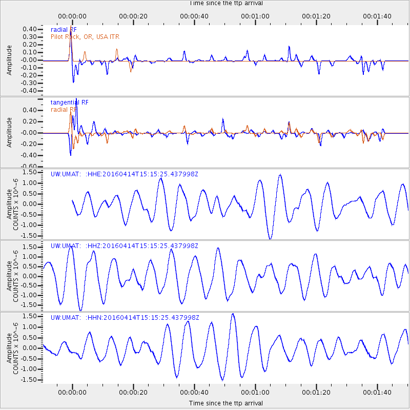
UMAT Pilot Rock, OR, USA - Earthquake Result Viewer
*The percent match for this event was below the threshold and hence no stack was calculated.
| Earthquake location: |
Kyushu, Japan |
| Earthquake latitude/longitude: |
32.7/130.7 |
| Earthquake time(UTC): |
2016/04/14 (105) 15:03:46 GMT |
| Earthquake Depth: |
1.3 km |
| Earthquake Magnitude: |
5.9 MWB |
| Earthquake Catalog/Contributor: |
NEIC PDE/NEIC COMCAT |
|
| Network: |
UW Pacific Northwest Regional Seismic Network |
| Station: |
UMAT Pilot Rock, OR, USA |
| Lat/Lon: |
45.29 N/118.96 W |
| Elevation: |
1318 m |
|
| Distance: |
79.9 deg |
| Az: |
42.247 deg |
| Baz: |
306.611 deg |
| Ray Param: |
$rayparam |
*The percent match for this event was below the threshold and hence was not used in the summary stack. |
|
| Radial Match: |
78.58534 % |
| Radial Bump: |
310 |
| Transverse Match: |
79.16721 % |
| Transverse Bump: |
367 |
| SOD ConfigId: |
7422571 |
| Insert Time: |
2019-04-22 06:34:28.270 +0000 |
| GWidth: |
2.5 |
| Max Bumps: |
400 |
| Tol: |
0.001 |
|
Signal To Noise
| Channel | StoN | STA | LTA |
| UW:UMAT: :HHZ:20160414T15:15:25.437998Z | 2.096136 | 1.2072452E-6 | 5.7593843E-7 |
| UW:UMAT: :HHN:20160414T15:15:25.437998Z | 0.67504084 | 2.7860813E-7 | 4.1272781E-7 |
| UW:UMAT: :HHE:20160414T15:15:25.437998Z | 2.07453 | 8.292216E-7 | 3.9971545E-7 |
| Arrivals |
| Ps | |
| PpPs | |
| PsPs/PpSs | |


