You are here: Home > Network List > NM - Cooperative New Madrid Seismic Network Stations List
> Station UTMT Martin, TN > Earthquake Result Viewer
UTMT Martin, TN - Earthquake Result Viewer
| Earthquake location: |
Panama-Colombia Border Region |
| Earthquake latitude/longitude: |
8.2/-77.3 |
| Earthquake time(UTC): |
2015/07/29 (210) 00:10:24 GMT |
| Earthquake Depth: |
10 km |
| Earthquake Magnitude: |
5.9 MWP, 6.1 MI |
| Earthquake Catalog/Contributor: |
NEIC PDE/NEIC COMCAT |
|
| Network: |
NM Cooperative New Madrid Seismic Network |
| Station: |
UTMT Martin, TN |
| Lat/Lon: |
36.35 N/88.86 W |
| Elevation: |
110 m |
|
| Distance: |
29.9 deg |
| Az: |
341.056 deg |
| Baz: |
156.545 deg |
| Ray Param: |
0.07947225 |
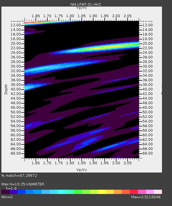
| Estimated Moho Depth: |
10.25 km |
| Estimated Crust Vp/Vs: |
1.60 |
| Assumed Crust Vp: |
6.444 km/s |
| Estimated Crust Vs: |
4.027 km/s |
| Estimated Crust Poisson's Ratio: |
0.18 |
|
| Radial Match: |
87.29972 % |
| Radial Bump: |
366 |
| Transverse Match: |
53.389526 % |
| Transverse Bump: |
378 |
| SOD ConfigId: |
1085051 |
| Insert Time: |
2015-08-12 00:26:42.372 +0000 |
| GWidth: |
2.5 |
| Max Bumps: |
400 |
| Tol: |
0.001 |
|
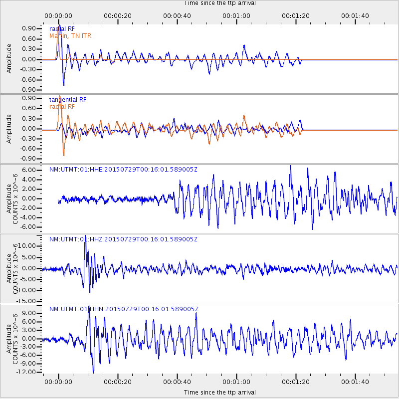
Signal To Noise
| Channel | StoN | STA | LTA |
| NM:UTMT:01:HHZ:20150729T00:16:01.589005Z | 4.3063974 | 1.1203056E-6 | 2.6014914E-7 |
| NM:UTMT:01:HHN:20150729T00:16:01.589005Z | 1.4473583 | 8.095592E-7 | 5.593358E-7 |
| NM:UTMT:01:HHE:20150729T00:16:01.589005Z | 0.92123073 | 3.5115517E-7 | 3.8118048E-7 |
| Arrivals |
| Ps | 1.0 SECOND |
| PpPs | 3.8 SECOND |
| PsPs/PpSs | 4.8 SECOND |


