You are here: Home > Network List > AT - Alaska Tsunami Warning Seismic System Stations List
> Station TTA Tatalina, Alaska > Earthquake Result Viewer
TTA Tatalina, Alaska - Earthquake Result Viewer
| Earthquake location: |
Vanuatu Islands |
| Earthquake latitude/longitude: |
-14.5/166.4 |
| Earthquake time(UTC): |
2016/04/14 (105) 21:50:26 GMT |
| Earthquake Depth: |
10 km |
| Earthquake Magnitude: |
6.5 MWP, 6.2 MWB, 6.6 MI |
| Earthquake Catalog/Contributor: |
NEIC PDE/NEIC COMCAT |
|
| Network: |
AT Alaska Tsunami Warning Seismic System |
| Station: |
TTA Tatalina, Alaska |
| Lat/Lon: |
62.93 N/156.01 W |
| Elevation: |
990 m |
|
| Distance: |
82.6 deg |
| Az: |
16.343 deg |
| Baz: |
216.554 deg |
| Ray Param: |
0.04678774 |
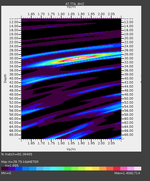
| Estimated Moho Depth: |
29.75 km |
| Estimated Crust Vp/Vs: |
1.88 |
| Assumed Crust Vp: |
6.182 km/s |
| Estimated Crust Vs: |
3.28 km/s |
| Estimated Crust Poisson's Ratio: |
0.30 |
|
| Radial Match: |
80.39485 % |
| Radial Bump: |
359 |
| Transverse Match: |
62.894764 % |
| Transverse Bump: |
400 |
| SOD ConfigId: |
7422571 |
| Insert Time: |
2019-04-22 06:37:41.388 +0000 |
| GWidth: |
2.5 |
| Max Bumps: |
400 |
| Tol: |
0.001 |
|

Signal To Noise
| Channel | StoN | STA | LTA |
| AT:TTA: :BHZ:20160414T22:02:18.240002Z | 9.376607 | 8.985134E-7 | 9.582501E-8 |
| AT:TTA: :BHN:20160414T22:02:18.240002Z | 2.333555 | 3.1483202E-7 | 1.349152E-7 |
| AT:TTA: :BHE:20160414T22:02:18.240002Z | 2.3186693 | 2.7807812E-7 | 1.1993004E-7 |
| Arrivals |
| Ps | 4.4 SECOND |
| PpPs | 14 SECOND |
| PsPs/PpSs | 18 SECOND |


