You are here: Home > Network List > CB - China National Seismic Network Stations List
> Station HEH Heihe,Heilongjiang Province > Earthquake Result Viewer
HEH Heihe,Heilongjiang Province - Earthquake Result Viewer
| Earthquake location: |
Vanuatu Islands |
| Earthquake latitude/longitude: |
-14.5/166.4 |
| Earthquake time(UTC): |
2016/04/14 (105) 21:50:26 GMT |
| Earthquake Depth: |
10 km |
| Earthquake Magnitude: |
6.5 MWP, 6.2 MWB, 6.6 MI |
| Earthquake Catalog/Contributor: |
NEIC PDE/NEIC COMCAT |
|
| Network: |
CB China National Seismic Network |
| Station: |
HEH Heihe,Heilongjiang Province |
| Lat/Lon: |
50.25 N/127.41 E |
| Elevation: |
165 m |
|
| Distance: |
73.0 deg |
| Az: |
335.019 deg |
| Baz: |
140.428 deg |
| Ray Param: |
0.053266 |
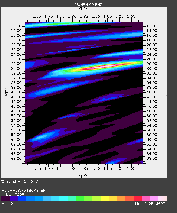
| Estimated Moho Depth: |
28.75 km |
| Estimated Crust Vp/Vs: |
1.94 |
| Assumed Crust Vp: |
6.419 km/s |
| Estimated Crust Vs: |
3.305 km/s |
| Estimated Crust Poisson's Ratio: |
0.32 |
|
| Radial Match: |
93.04302 % |
| Radial Bump: |
400 |
| Transverse Match: |
70.34401 % |
| Transverse Bump: |
400 |
| SOD ConfigId: |
7422571 |
| Insert Time: |
2019-04-22 06:38:35.939 +0000 |
| GWidth: |
2.5 |
| Max Bumps: |
400 |
| Tol: |
0.001 |
|
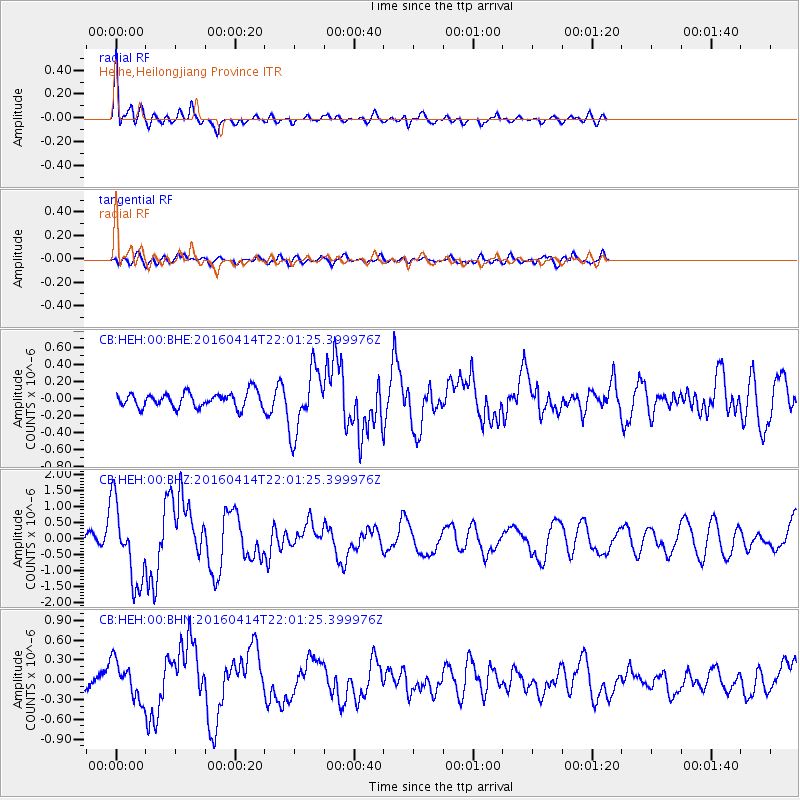
Signal To Noise
| Channel | StoN | STA | LTA |
| CB:HEH:00:BHZ:20160414T22:01:25.399976Z | 10.525173 | 1.2295529E-6 | 1.1682021E-7 |
| CB:HEH:00:BHN:20160414T22:01:25.399976Z | 4.0235853 | 2.89749E-7 | 7.201265E-8 |
| CB:HEH:00:BHE:20160414T22:01:25.399976Z | 4.077779 | 3.6384088E-7 | 8.922526E-8 |
| Arrivals |
| Ps | 4.4 SECOND |
| PpPs | 13 SECOND |
| PsPs/PpSs | 17 SECOND |


