You are here: Home > Network List > US - United States National Seismic Network Stations List
> Station AGMN Agassiz National Wildlife Refuge, Minnesota, USA > Earthquake Result Viewer
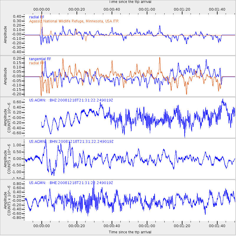
AGMN Agassiz National Wildlife Refuge, Minnesota, USA - Earthquake Result Viewer
*The percent match for this event was below the threshold and hence no stack was calculated.
| Earthquake location: |
Near Coast Of Central Chile |
| Earthquake latitude/longitude: |
-32.5/-71.7 |
| Earthquake time(UTC): |
2008/12/18 (353) 21:19:28 GMT |
| Earthquake Depth: |
18 km |
| Earthquake Magnitude: |
5.8 MB, 6.0 MS, 6.2 MW, 6.1 MW |
| Earthquake Catalog/Contributor: |
WHDF/NEIC |
|
| Network: |
US United States National Seismic Network |
| Station: |
AGMN Agassiz National Wildlife Refuge, Minnesota, USA |
| Lat/Lon: |
48.30 N/95.86 W |
| Elevation: |
351 m |
|
| Distance: |
83.2 deg |
| Az: |
344.041 deg |
| Baz: |
159.629 deg |
| Ray Param: |
$rayparam |
*The percent match for this event was below the threshold and hence was not used in the summary stack. |
|
| Radial Match: |
50.880978 % |
| Radial Bump: |
400 |
| Transverse Match: |
51.467255 % |
| Transverse Bump: |
359 |
| SOD ConfigId: |
2658 |
| Insert Time: |
2010-03-05 01:26:43.310 +0000 |
| GWidth: |
2.5 |
| Max Bumps: |
400 |
| Tol: |
0.001 |
|
Signal To Noise
| Channel | StoN | STA | LTA |
| US:AGMN: :BHN:20081218T21:31:22.249019Z | 2.9942453 | 6.520046E-7 | 2.1775256E-7 |
| US:AGMN: :BHE:20081218T21:31:22.249019Z | 1.1933054 | 2.210015E-7 | 1.8520113E-7 |
| US:AGMN: :BHZ:20081218T21:31:22.249019Z | 1.8852276 | 4.1397848E-7 | 2.1959073E-7 |
| Arrivals |
| Ps | |
| PpPs | |
| PsPs/PpSs | |


