You are here: Home > Network List > TA - USArray Transportable Network (new EarthScope stations) Stations List
> Station I21K Tanana, AK, USA > Earthquake Result Viewer
I21K Tanana, AK, USA - Earthquake Result Viewer
| Earthquake location: |
Vanuatu Islands |
| Earthquake latitude/longitude: |
-14.5/166.4 |
| Earthquake time(UTC): |
2016/04/14 (105) 21:50:26 GMT |
| Earthquake Depth: |
10 km |
| Earthquake Magnitude: |
6.5 MWP, 6.2 MWB, 6.6 MI |
| Earthquake Catalog/Contributor: |
NEIC PDE/NEIC COMCAT |
|
| Network: |
TA USArray Transportable Network (new EarthScope stations) |
| Station: |
I21K Tanana, AK, USA |
| Lat/Lon: |
65.18 N/151.98 W |
| Elevation: |
248 m |
|
| Distance: |
85.5 deg |
| Az: |
16.331 deg |
| Baz: |
220.173 deg |
| Ray Param: |
0.044754364 |
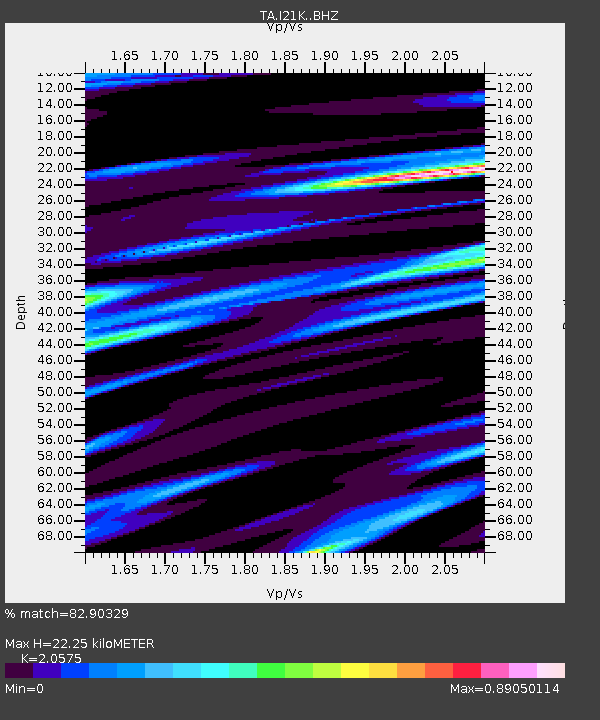
| Estimated Moho Depth: |
22.25 km |
| Estimated Crust Vp/Vs: |
2.06 |
| Assumed Crust Vp: |
6.566 km/s |
| Estimated Crust Vs: |
3.191 km/s |
| Estimated Crust Poisson's Ratio: |
0.35 |
|
| Radial Match: |
82.90329 % |
| Radial Bump: |
400 |
| Transverse Match: |
81.10169 % |
| Transverse Bump: |
400 |
| SOD ConfigId: |
7422571 |
| Insert Time: |
2019-04-22 06:42:02.397 +0000 |
| GWidth: |
2.5 |
| Max Bumps: |
400 |
| Tol: |
0.001 |
|

Signal To Noise
| Channel | StoN | STA | LTA |
| TA:I21K: :BHZ:20160414T22:02:32.825024Z | 10.389773 | 1.3631424E-6 | 1.312004E-7 |
| TA:I21K: :BHN:20160414T22:02:32.825024Z | 2.750342 | 4.9626794E-7 | 1.8043863E-7 |
| TA:I21K: :BHE:20160414T22:02:32.825024Z | 2.0053246 | 3.1204544E-7 | 1.5560845E-7 |
| Arrivals |
| Ps | 3.7 SECOND |
| PpPs | 10 SECOND |
| PsPs/PpSs | 14 SECOND |


