You are here: Home > Network List > UW - Pacific Northwest Regional Seismic Network Stations List
> Station PASS Maple Falls, WA, USA > Earthquake Result Viewer
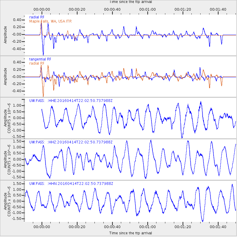
PASS Maple Falls, WA, USA - Earthquake Result Viewer
*The percent match for this event was below the threshold and hence no stack was calculated.
| Earthquake location: |
Vanuatu Islands |
| Earthquake latitude/longitude: |
-14.5/166.4 |
| Earthquake time(UTC): |
2016/04/14 (105) 21:50:26 GMT |
| Earthquake Depth: |
10 km |
| Earthquake Magnitude: |
6.5 MWP, 6.2 MWB, 6.6 MI |
| Earthquake Catalog/Contributor: |
NEIC PDE/NEIC COMCAT |
|
| Network: |
UW Pacific Northwest Regional Seismic Network |
| Station: |
PASS Maple Falls, WA, USA |
| Lat/Lon: |
49.00 N/122.09 W |
| Elevation: |
174 m |
|
| Distance: |
89.2 deg |
| Az: |
38.657 deg |
| Baz: |
246.7 deg |
| Ray Param: |
$rayparam |
*The percent match for this event was below the threshold and hence was not used in the summary stack. |
|
| Radial Match: |
75.39789 % |
| Radial Bump: |
400 |
| Transverse Match: |
66.64857 % |
| Transverse Bump: |
265 |
| SOD ConfigId: |
7422571 |
| Insert Time: |
2019-04-22 06:43:05.507 +0000 |
| GWidth: |
2.5 |
| Max Bumps: |
400 |
| Tol: |
0.001 |
|
Signal To Noise
| Channel | StoN | STA | LTA |
| UW:PASS: :HHZ:20160414T22:02:50.737988Z | 2.2862937 | 9.678703E-7 | 4.2333593E-7 |
| UW:PASS: :HHN:20160414T22:02:50.737988Z | 0.8702914 | 4.3040535E-7 | 4.9455315E-7 |
| UW:PASS: :HHE:20160414T22:02:50.737988Z | 1.2870433 | 7.2079536E-7 | 5.600397E-7 |
| Arrivals |
| Ps | |
| PpPs | |
| PsPs/PpSs | |


