You are here: Home > Network List > US - United States National Seismic Network Stations List
> Station DGMT Dagmar, Montana, USA > Earthquake Result Viewer
DGMT Dagmar, Montana, USA - Earthquake Result Viewer
| Earthquake location: |
Volcano Islands, Japan Region |
| Earthquake latitude/longitude: |
22.0/142.7 |
| Earthquake time(UTC): |
2007/09/28 (271) 13:38:59 GMT |
| Earthquake Depth: |
276 km |
| Earthquake Magnitude: |
6.7 MB, 7.4 MW, 7.4 MW |
| Earthquake Catalog/Contributor: |
WHDF/NEIC |
|
| Network: |
US United States National Seismic Network |
| Station: |
DGMT Dagmar, Montana, USA |
| Lat/Lon: |
48.47 N/104.20 W |
| Elevation: |
0.0 m |
|
| Distance: |
88.0 deg |
| Az: |
37.754 deg |
| Baz: |
301.372 deg |
| Ray Param: |
0.04225003 |
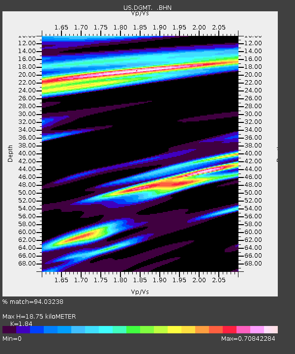
| Estimated Moho Depth: |
18.75 km |
| Estimated Crust Vp/Vs: |
1.84 |
| Assumed Crust Vp: |
6.438 km/s |
| Estimated Crust Vs: |
3.499 km/s |
| Estimated Crust Poisson's Ratio: |
0.29 |
|
| Radial Match: |
94.03238 % |
| Radial Bump: |
400 |
| Transverse Match: |
75.68641 % |
| Transverse Bump: |
400 |
| SOD ConfigId: |
2564 |
| Insert Time: |
2010-03-05 01:26:53.002 +0000 |
| GWidth: |
2.5 |
| Max Bumps: |
400 |
| Tol: |
0.001 |
|
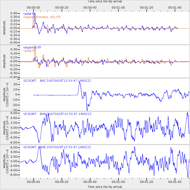
Signal To Noise
| Channel | StoN | STA | LTA |
| US:DGMT: :BHN:20070928T13:50:47.148022Z | 8.898694 | 2.94366E-6 | 3.3079687E-7 |
| US:DGMT: :BHE:20070928T13:50:47.148022Z | 8.821188 | 3.3521878E-6 | 3.8001545E-7 |
| US:DGMT: :BHZ:20070928T13:50:47.148022Z | 72.999504 | 1.1634948E-5 | 1.5938393E-7 |
| Arrivals |
| Ps | 2.5 SECOND |
| PpPs | 8.1 SECOND |
| PsPs/PpSs | 11 SECOND |


