You are here: Home > Network List > US - United States National Seismic Network Stations List
> Station DGMT Dagmar, Montana, USA > Earthquake Result Viewer
DGMT Dagmar, Montana, USA - Earthquake Result Viewer
| Earthquake location: |
Kuril Islands |
| Earthquake latitude/longitude: |
51.0/157.6 |
| Earthquake time(UTC): |
2008/07/24 (206) 01:43:16 GMT |
| Earthquake Depth: |
27 km |
| Earthquake Magnitude: |
6.0 MB, 6.0 MS, 6.2 MW, 6.2 MW |
| Earthquake Catalog/Contributor: |
WHDF/NEIC |
|
| Network: |
US United States National Seismic Network |
| Station: |
DGMT Dagmar, Montana, USA |
| Lat/Lon: |
48.47 N/104.20 W |
| Elevation: |
0.0 m |
|
| Distance: |
58.8 deg |
| Az: |
50.359 deg |
| Baz: |
312.974 deg |
| Ray Param: |
0.06256886 |
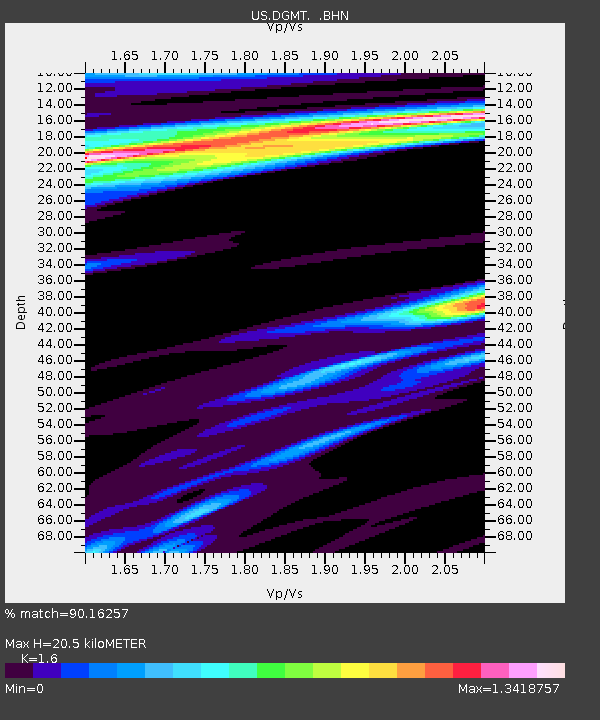
| Estimated Moho Depth: |
20.5 km |
| Estimated Crust Vp/Vs: |
1.60 |
| Assumed Crust Vp: |
6.438 km/s |
| Estimated Crust Vs: |
4.023 km/s |
| Estimated Crust Poisson's Ratio: |
0.18 |
|
| Radial Match: |
90.16257 % |
| Radial Bump: |
393 |
| Transverse Match: |
64.544174 % |
| Transverse Bump: |
400 |
| SOD ConfigId: |
2504 |
| Insert Time: |
2010-03-05 01:26:56.885 +0000 |
| GWidth: |
2.5 |
| Max Bumps: |
400 |
| Tol: |
0.001 |
|

Signal To Noise
| Channel | StoN | STA | LTA |
| US:DGMT: :BHN:20080724T01:52:41.048997Z | 14.271466 | 2.5234335E-6 | 1.768167E-7 |
| US:DGMT: :BHE:20080724T01:52:41.048997Z | 2.160635 | 7.5404773E-7 | 3.4899355E-7 |
| US:DGMT: :BHZ:20080724T01:52:41.048997Z | 2.0604267 | 5.004337E-7 | 2.4287868E-7 |
| Arrivals |
| Ps | 2.0 SECOND |
| PpPs | 7.8 SECOND |
| PsPs/PpSs | 9.9 SECOND |


