You are here: Home > Network List > US - United States National Seismic Network Stations List
> Station DGMT Dagmar, Montana, USA > Earthquake Result Viewer
DGMT Dagmar, Montana, USA - Earthquake Result Viewer
| Earthquake location: |
Eastern Honshu, Japan |
| Earthquake latitude/longitude: |
37.1/140.9 |
| Earthquake time(UTC): |
2005/10/22 (295) 13:12:47 GMT |
| Earthquake Depth: |
53 km |
| Earthquake Magnitude: |
5.6 MB, 5.6 MW |
| Earthquake Catalog/Contributor: |
WHDF/NEIC |
|
| Network: |
US United States National Seismic Network |
| Station: |
DGMT Dagmar, Montana, USA |
| Lat/Lon: |
48.47 N/104.20 W |
| Elevation: |
0.0 m |
|
| Distance: |
77.0 deg |
| Az: |
38.293 deg |
| Baz: |
311.926 deg |
| Ray Param: |
0.050525233 |
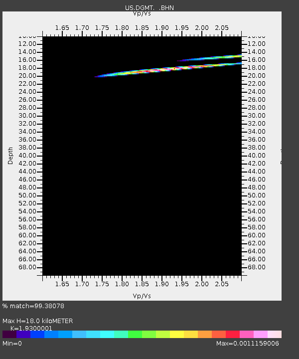
| Estimated Moho Depth: |
18.0 km |
| Estimated Crust Vp/Vs: |
1.93 |
| Assumed Crust Vp: |
6.438 km/s |
| Estimated Crust Vs: |
3.335 km/s |
| Estimated Crust Poisson's Ratio: |
0.32 |
|
| Radial Match: |
99.38078 % |
| Radial Bump: |
53 |
| Transverse Match: |
92.32365 % |
| Transverse Bump: |
73 |
| SOD ConfigId: |
2669 |
| Insert Time: |
2010-03-05 01:27:02.131 +0000 |
| GWidth: |
2.5 |
| Max Bumps: |
400 |
| Tol: |
0.001 |
|
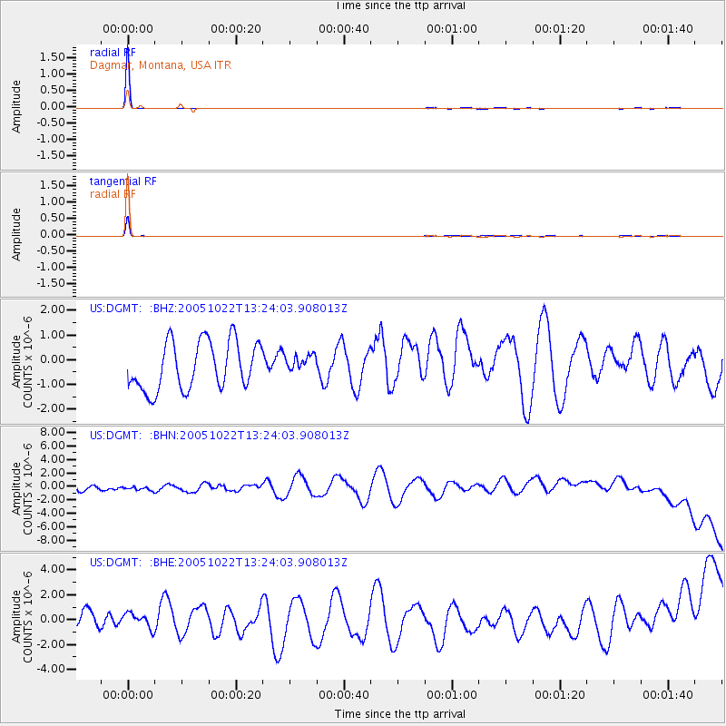
Signal To Noise
| Channel | StoN | STA | LTA |
| US:DGMT: :BHN:20051022T13:24:03.908013Z | 0.7922573 | 7.177889E-7 | 9.0600474E-7 |
| US:DGMT: :BHE:20051022T13:24:03.908013Z | 0.433807 | 8.170945E-7 | 1.883544E-6 |
| US:DGMT: :BHZ:20051022T13:24:03.908013Z | 0.36718032 | 3.560951E-7 | 9.698099E-7 |
| Arrivals |
| Ps | 2.7 SECOND |
| PpPs | 8.0 SECOND |
| PsPs/PpSs | 11 SECOND |


