You are here: Home > Network List > US - United States National Seismic Network Stations List
> Station DGMT Dagmar, Montana, USA > Earthquake Result Viewer
DGMT Dagmar, Montana, USA - Earthquake Result Viewer
| Earthquake location: |
Aegean Sea |
| Earthquake latitude/longitude: |
38.2/26.8 |
| Earthquake time(UTC): |
2005/10/20 (293) 21:40:04 GMT |
| Earthquake Depth: |
10 km |
| Earthquake Magnitude: |
5.5 MB, 5.7 MS, 5.9 MW, 5.9 MW |
| Earthquake Catalog/Contributor: |
WHDF/NEIC |
|
| Network: |
US United States National Seismic Network |
| Station: |
DGMT Dagmar, Montana, USA |
| Lat/Lon: |
48.47 N/104.20 W |
| Elevation: |
0.0 m |
|
| Distance: |
83.4 deg |
| Az: |
329.599 deg |
| Baz: |
36.833 deg |
| Ray Param: |
0.046231434 |
| Estimated Moho Depth: |
10.0 km |
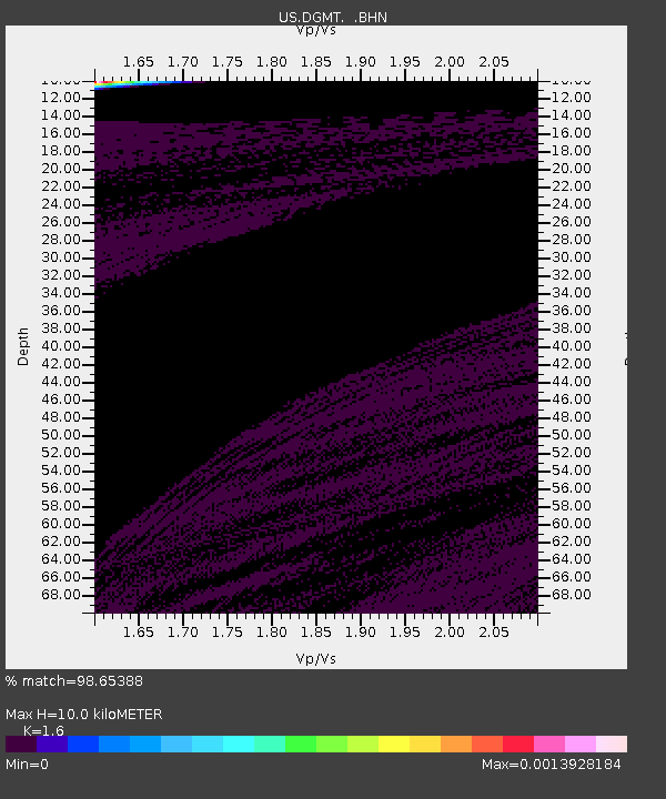
| Estimated Crust Vp/Vs: |
1.60 |
| Assumed Crust Vp: |
6.438 km/s |
| Estimated Crust Vs: |
4.023 km/s |
| Estimated Crust Poisson's Ratio: |
0.18 |
|
| Radial Match: |
98.65388 % |
| Radial Bump: |
53 |
| Transverse Match: |
99.51972 % |
| Transverse Bump: |
31 |
| SOD ConfigId: |
2669 |
| Insert Time: |
2010-03-05 01:27:03.537 +0000 |
| GWidth: |
2.5 |
| Max Bumps: |
400 |
| Tol: |
0.001 |
|
Signal To Noise
| Channel | StoN | STA | LTA |
| US:DGMT: :BHN:20051020T21:51:59.858005Z | 1.0830956 | 9.630758E-7 | 8.891881E-7 |
| US:DGMT: :BHE:20051020T21:51:59.858005Z | 1.5100654 | 1.3802916E-6 | 9.1406076E-7 |
| US:DGMT: :BHZ:20051020T21:51:59.858005Z | 0.598235 | 4.4163193E-7 | 7.3822486E-7 |
| Arrivals |
| Ps | 1.0 SECOND |
| PpPs | 3.9 SECOND |
| PsPs/PpSs | 4.9 SECOND |


