You are here: Home > Network List > US - United States National Seismic Network Stations List
> Station DGMT Dagmar, Montana, USA > Earthquake Result Viewer
DGMT Dagmar, Montana, USA - Earthquake Result Viewer
| Earthquake location: |
Pakistan |
| Earthquake latitude/longitude: |
34.8/73.0 |
| Earthquake time(UTC): |
2005/10/19 (292) 02:33:28 GMT |
| Earthquake Depth: |
5.0 km |
| Earthquake Magnitude: |
5.6 MB, 5.4 MS, 5.6 MW, 5.5 MW |
| Earthquake Catalog/Contributor: |
WHDF/NEIC |
|
| Network: |
US United States National Seismic Network |
| Station: |
DGMT Dagmar, Montana, USA |
| Lat/Lon: |
48.47 N/104.20 W |
| Elevation: |
0.0 m |
|
| Distance: |
97.1 deg |
| Az: |
358.144 deg |
| Baz: |
2.296 deg |
| Ray Param: |
0.04031551 |
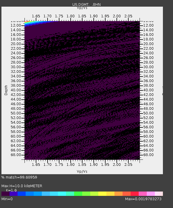
| Estimated Moho Depth: |
10.0 km |
| Estimated Crust Vp/Vs: |
1.60 |
| Assumed Crust Vp: |
6.438 km/s |
| Estimated Crust Vs: |
4.023 km/s |
| Estimated Crust Poisson's Ratio: |
0.18 |
|
| Radial Match: |
99.68959 % |
| Radial Bump: |
25 |
| Transverse Match: |
98.81906 % |
| Transverse Bump: |
37 |
| SOD ConfigId: |
2669 |
| Insert Time: |
2010-03-05 01:27:07.459 +0000 |
| GWidth: |
2.5 |
| Max Bumps: |
400 |
| Tol: |
0.001 |
|

Signal To Noise
| Channel | StoN | STA | LTA |
| US:DGMT: :BHN:20051019T02:46:29.658022Z | 0.8655032 | 6.9672217E-7 | 8.0499086E-7 |
| US:DGMT: :BHE:20051019T02:46:29.658022Z | 1.9581908 | 1.2347504E-6 | 6.305567E-7 |
| US:DGMT: :BHZ:20051019T02:46:29.658022Z | 1.3030423 | 6.9466495E-7 | 5.331101E-7 |
| Arrivals |
| Ps | 1.0 SECOND |
| PpPs | 4.0 SECOND |
| PsPs/PpSs | 4.9 SECOND |


