You are here: Home > Network List > US - United States National Seismic Network Stations List
> Station LONY Lake Ozonia, New York, USA > Earthquake Result Viewer
LONY Lake Ozonia, New York, USA - Earthquake Result Viewer
| Earthquake location: |
Panama-Colombia Border Region |
| Earthquake latitude/longitude: |
8.2/-77.3 |
| Earthquake time(UTC): |
2015/07/29 (210) 00:10:24 GMT |
| Earthquake Depth: |
10 km |
| Earthquake Magnitude: |
5.9 MWP, 6.1 MI |
| Earthquake Catalog/Contributor: |
NEIC PDE/NEIC COMCAT |
|
| Network: |
US United States National Seismic Network |
| Station: |
LONY Lake Ozonia, New York, USA |
| Lat/Lon: |
44.62 N/74.58 W |
| Elevation: |
440 m |
|
| Distance: |
36.3 deg |
| Az: |
3.275 deg |
| Baz: |
184.541 deg |
| Ray Param: |
0.07674407 |
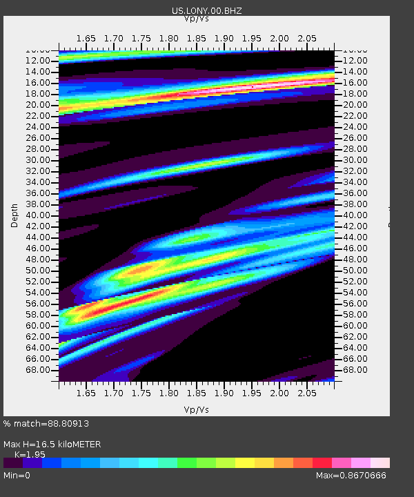
| Estimated Moho Depth: |
16.5 km |
| Estimated Crust Vp/Vs: |
1.95 |
| Assumed Crust Vp: |
6.419 km/s |
| Estimated Crust Vs: |
3.292 km/s |
| Estimated Crust Poisson's Ratio: |
0.32 |
|
| Radial Match: |
88.80913 % |
| Radial Bump: |
340 |
| Transverse Match: |
79.43663 % |
| Transverse Bump: |
390 |
| SOD ConfigId: |
1085051 |
| Insert Time: |
2015-08-12 00:33:23.845 +0000 |
| GWidth: |
2.5 |
| Max Bumps: |
400 |
| Tol: |
0.001 |
|
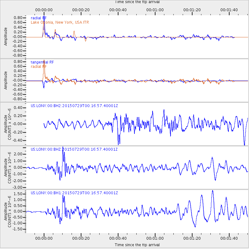
Signal To Noise
| Channel | StoN | STA | LTA |
| US:LONY:00:BHZ:20150729T00:16:57.40001Z | 3.1071858 | 1.7264335E-7 | 5.556261E-8 |
| US:LONY:00:BH1:20150729T00:16:57.40001Z | 2.357582 | 1.2819372E-7 | 5.4375086E-8 |
| US:LONY:00:BH2:20150729T00:16:57.40001Z | 0.9151204 | 5.2643642E-8 | 5.7526464E-8 |
| Arrivals |
| Ps | 2.6 SECOND |
| PpPs | 7.1 SECOND |
| PsPs/PpSs | 9.7 SECOND |


