You are here: Home > Network List > US - United States National Seismic Network Stations List
> Station DGMT Dagmar, Montana, USA > Earthquake Result Viewer
DGMT Dagmar, Montana, USA - Earthquake Result Viewer
| Earthquake location: |
Aegean Sea |
| Earthquake latitude/longitude: |
38.2/26.5 |
| Earthquake time(UTC): |
2005/10/17 (290) 09:46:53 GMT |
| Earthquake Depth: |
10 km |
| Earthquake Magnitude: |
5.4 MB, 5.7 MS, 5.8 MW, 5.8 MW |
| Earthquake Catalog/Contributor: |
WHDF/NEIC |
|
| Network: |
US United States National Seismic Network |
| Station: |
DGMT Dagmar, Montana, USA |
| Lat/Lon: |
48.47 N/104.20 W |
| Elevation: |
0.0 m |
|
| Distance: |
83.2 deg |
| Az: |
329.462 deg |
| Baz: |
36.98 deg |
| Ray Param: |
0.046331674 |
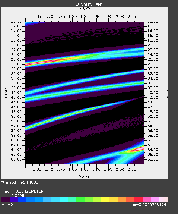
| Estimated Moho Depth: |
63.0 km |
| Estimated Crust Vp/Vs: |
2.09 |
| Assumed Crust Vp: |
6.438 km/s |
| Estimated Crust Vs: |
3.076 km/s |
| Estimated Crust Poisson's Ratio: |
0.35 |
|
| Radial Match: |
96.14863 % |
| Radial Bump: |
75 |
| Transverse Match: |
98.7067 % |
| Transverse Bump: |
47 |
| SOD ConfigId: |
2669 |
| Insert Time: |
2010-03-05 01:27:08.701 +0000 |
| GWidth: |
2.5 |
| Max Bumps: |
400 |
| Tol: |
0.001 |
|
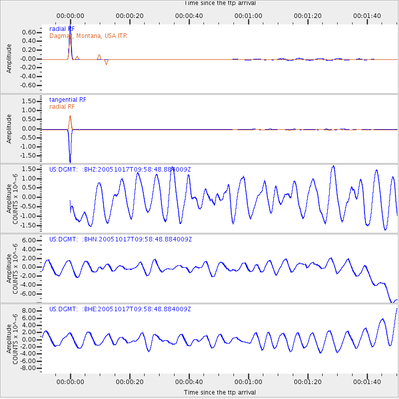
Signal To Noise
| Channel | StoN | STA | LTA |
| US:DGMT: :BHN:20051017T09:58:48.884009Z | 1.3767346 | 1.5766204E-6 | 1.1451883E-6 |
| US:DGMT: :BHE:20051017T09:58:48.884009Z | 1.0499288 | 1.5245903E-6 | 1.4520892E-6 |
| US:DGMT: :BHZ:20051017T09:58:48.884009Z | 1.3918281 | 1.1429299E-6 | 8.211718E-7 |
| Arrivals |
| Ps | 11 SECOND |
| PpPs | 30 SECOND |
| PsPs/PpSs | 41 SECOND |


