You are here: Home > Network List > US - United States National Seismic Network Stations List
> Station DGMT Dagmar, Montana, USA > Earthquake Result Viewer
DGMT Dagmar, Montana, USA - Earthquake Result Viewer

| Earthquake location: |
Pakistan |
| Earthquake latitude/longitude: |
34.9/73.1 |
| Earthquake time(UTC): |
2005/10/12 (285) 20:23:38 GMT |
| Earthquake Depth: |
10 km |
| Earthquake Magnitude: |
5.6 MB, 5.0 MS, 5.4 MW, 5.3 MW |
| Earthquake Catalog/Contributor: |
WHDF/NEIC |
|
| Network: |
US United States National Seismic Network |
| Station: |
DGMT Dagmar, Montana, USA |
| Lat/Lon: |
48.47 N/104.20 W |
| Elevation: |
0.0 m |
|
| Distance: |
97.0 deg |
| Az: |
358.193 deg |
| Baz: |
2.233 deg |
| Ray Param: |
0.04034384 |
| Estimated Moho Depth: |
10.0 km |
| Estimated Crust Vp/Vs: |
1.60 |
| Assumed Crust Vp: |
6.438 km/s |
| Estimated Crust Vs: |
4.023 km/s |
| Estimated Crust Poisson's Ratio: |
0.18 |
|
| Radial Match: |
99.71975 % |
| Radial Bump: |
23 |
| Transverse Match: |
99.51363 % |
| Transverse Bump: |
35 |
| SOD ConfigId: |
2669 |
| Insert Time: |
2010-03-05 01:27:10.251 +0000 |
| GWidth: |
2.5 |
| Max Bumps: |
400 |
| Tol: |
0.001 |
|
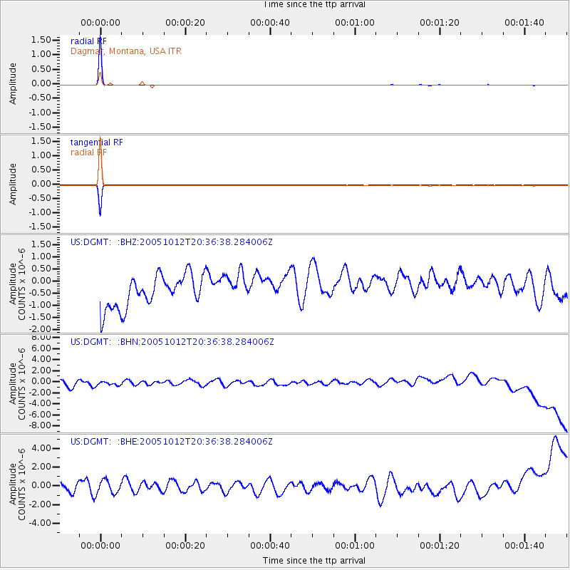
Signal To Noise
| Channel | StoN | STA | LTA |
| US:DGMT: :BHN:20051012T20:36:38.284006Z | 0.86824876 | 7.265915E-7 | 8.3684716E-7 |
| US:DGMT: :BHE:20051012T20:36:38.284006Z | 1.076291 | 7.2706615E-7 | 6.7552935E-7 |
| US:DGMT: :BHZ:20051012T20:36:38.284006Z | 0.9201248 | 6.113204E-7 | 6.6438855E-7 |
| Arrivals |
| Ps | 1.0 SECOND |
| PpPs | 4.0 SECOND |
| PsPs/PpSs | 4.9 SECOND |


