You are here: Home > Network List > KN - Kyrgyz Seismic Telemetry Network Stations List
> Station TKM2 - > Earthquake Result Viewer
TKM2 - - Earthquake Result Viewer
*The percent match for this event was below the threshold and hence no stack was calculated.
| Earthquake location: |
Banda Sea |
| Earthquake latitude/longitude: |
-7.5/128.1 |
| Earthquake time(UTC): |
2016/04/14 (105) 23:15:07 GMT |
| Earthquake Depth: |
129 km |
| Earthquake Magnitude: |
5.7 MB |
| Earthquake Catalog/Contributor: |
NEIC PDE/NEIC COMCAT |
|
| Network: |
KN Kyrgyz Seismic Telemetry Network |
| Station: |
TKM2 - |
| Lat/Lon: |
42.92 N/75.60 E |
| Elevation: |
2020 m |
|
| Distance: |
69.1 deg |
| Az: |
321.438 deg |
| Baz: |
122.704 deg |
| Ray Param: |
$rayparam |
*The percent match for this event was below the threshold and hence was not used in the summary stack. |
|
| Radial Match: |
83.77483 % |
| Radial Bump: |
340 |
| Transverse Match: |
85.15774 % |
| Transverse Bump: |
400 |
| SOD ConfigId: |
7422571 |
| Insert Time: |
2019-04-22 06:47:23.138 +0000 |
| GWidth: |
2.5 |
| Max Bumps: |
400 |
| Tol: |
0.001 |
|
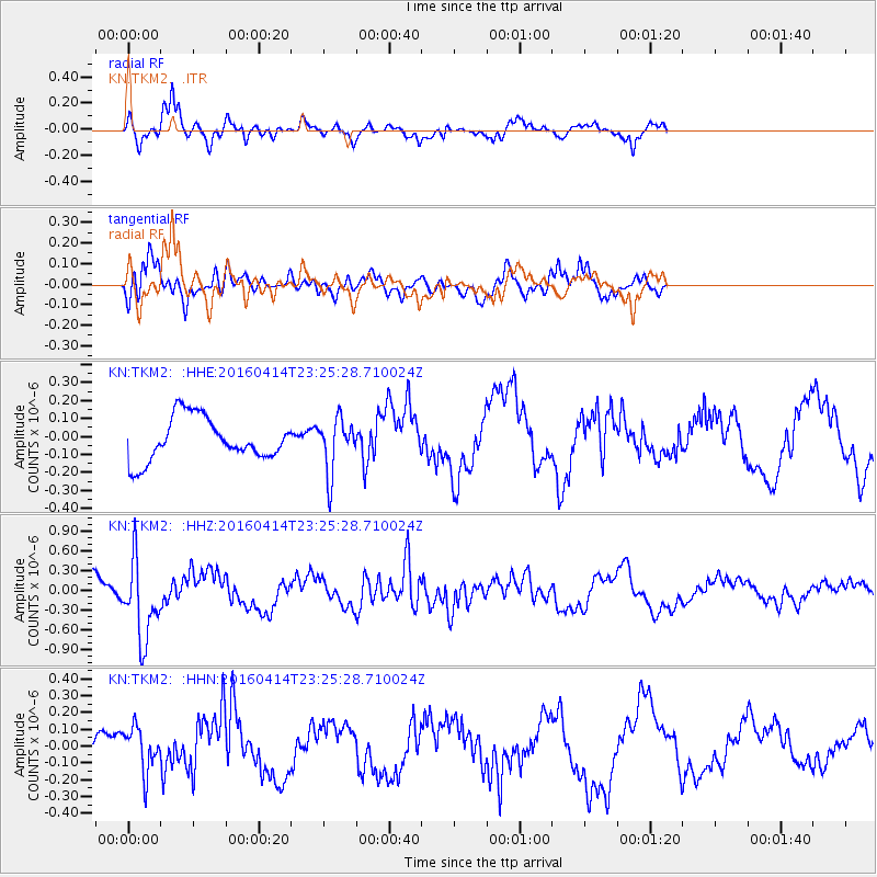
Signal To Noise
| Channel | StoN | STA | LTA |
| KN:TKM2: :HHZ:20160414T23:25:28.710024Z | 3.513938 | 6.065459E-7 | 1.7261144E-7 |
| KN:TKM2: :HHN:20160414T23:25:28.710024Z | 1.8276558 | 1.314538E-7 | 7.192481E-8 |
| KN:TKM2: :HHE:20160414T23:25:28.710024Z | 1.2448455 | 1.4917995E-7 | 1.1983813E-7 |
| Arrivals |
| Ps | |
| PpPs | |
| PsPs/PpSs | |


