You are here: Home > Network List > US - United States National Seismic Network Stations List
> Station DGMT Dagmar, Montana, USA > Earthquake Result Viewer
DGMT Dagmar, Montana, USA - Earthquake Result Viewer
| Earthquake location: |
Pakistan |
| Earthquake latitude/longitude: |
34.6/73.2 |
| Earthquake time(UTC): |
2005/10/09 (282) 07:09:18 GMT |
| Earthquake Depth: |
10 km |
| Earthquake Magnitude: |
5.5 MB, 4.6 MS, 5.4 MW |
| Earthquake Catalog/Contributor: |
WHDF/NEIC |
|
| Network: |
US United States National Seismic Network |
| Station: |
DGMT Dagmar, Montana, USA |
| Lat/Lon: |
48.47 N/104.20 W |
| Elevation: |
0.0 m |
|
| Distance: |
97.3 deg |
| Az: |
358.225 deg |
| Baz: |
2.202 deg |
| Ray Param: |
0.040256556 |
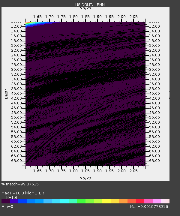
| Estimated Moho Depth: |
10.0 km |
| Estimated Crust Vp/Vs: |
1.60 |
| Assumed Crust Vp: |
6.438 km/s |
| Estimated Crust Vs: |
4.023 km/s |
| Estimated Crust Poisson's Ratio: |
0.18 |
|
| Radial Match: |
99.87525 % |
| Radial Bump: |
18 |
| Transverse Match: |
99.77395 % |
| Transverse Bump: |
30 |
| SOD ConfigId: |
2669 |
| Insert Time: |
2010-03-05 01:27:15.479 +0000 |
| GWidth: |
2.5 |
| Max Bumps: |
400 |
| Tol: |
0.001 |
|
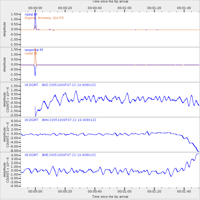
Signal To Noise
| Channel | StoN | STA | LTA |
| US:DGMT: :BHN:20051009T07:22:19.908013Z | 0.91324425 | 6.764048E-7 | 7.406614E-7 |
| US:DGMT: :BHE:20051009T07:22:19.908013Z | 1.0065871 | 5.616797E-7 | 5.5800405E-7 |
| US:DGMT: :BHZ:20051009T07:22:19.908013Z | 0.6093856 | 3.9442827E-7 | 6.4725566E-7 |
| Arrivals |
| Ps | 1.0 SECOND |
| PpPs | 4.0 SECOND |
| PsPs/PpSs | 4.9 SECOND |


