You are here: Home > Network List > XL12 - Hangay Dome, Mongolia Stations List
> Station AT06 AT06 > Earthquake Result Viewer
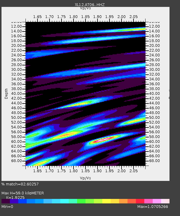
AT06 AT06 - Earthquake Result Viewer
| Earthquake location: |
Banda Sea |
| Earthquake latitude/longitude: |
-7.5/128.1 |
| Earthquake time(UTC): |
2016/04/14 (105) 23:15:07 GMT |
| Earthquake Depth: |
129 km |
| Earthquake Magnitude: |
5.7 MB |
| Earthquake Catalog/Contributor: |
NEIC PDE/NEIC COMCAT |
|
| Network: |
XL Hangay Dome, Mongolia |
| Station: |
AT06 AT06 |
| Lat/Lon: |
46.35 N/96.51 E |
| Elevation: |
2047 m |
|
| Distance: |
60.5 deg |
| Az: |
335.395 deg |
| Baz: |
143.413 deg |
| Ray Param: |
0.061085716 |
| Estimated Moho Depth: |
59.0 km |
| Estimated Crust Vp/Vs: |
1.92 |
| Assumed Crust Vp: |
6.642 km/s |
| Estimated Crust Vs: |
3.455 km/s |
| Estimated Crust Poisson's Ratio: |
0.31 |
|
| Radial Match: |
82.60257 % |
| Radial Bump: |
400 |
| Transverse Match: |
54.29018 % |
| Transverse Bump: |
400 |
| SOD ConfigId: |
7422571 |
| Insert Time: |
2019-04-22 06:48:16.830 +0000 |
| GWidth: |
2.5 |
| Max Bumps: |
400 |
| Tol: |
0.001 |
|

Signal To Noise
| Channel | StoN | STA | LTA |
| XL:AT06: :HHZ:20160414T23:24:32.969973Z | 2.1995132 | 5.2434893E-7 | 2.3839316E-7 |
| XL:AT06: :HHN:20160414T23:24:32.969973Z | 3.3212552 | 1.7707102E-7 | 5.3314483E-8 |
| XL:AT06: :HHE:20160414T23:24:32.969973Z | 2.972422 | 2.2707349E-7 | 7.639342E-8 |
| Arrivals |
| Ps | 8.6 SECOND |
| PpPs | 25 SECOND |
| PsPs/PpSs | 33 SECOND |


