You are here: Home > Network List > US - United States National Seismic Network Stations List
> Station DGMT Dagmar, Montana, USA > Earthquake Result Viewer
DGMT Dagmar, Montana, USA - Earthquake Result Viewer
| Earthquake location: |
Pakistan |
| Earthquake latitude/longitude: |
34.8/73.2 |
| Earthquake time(UTC): |
2005/10/08 (281) 05:26:05 GMT |
| Earthquake Depth: |
10 km |
| Earthquake Magnitude: |
5.5 MB |
| Earthquake Catalog/Contributor: |
WHDF/NEIC |
|
| Network: |
US United States National Seismic Network |
| Station: |
DGMT Dagmar, Montana, USA |
| Lat/Lon: |
48.47 N/104.20 W |
| Elevation: |
0.0 m |
|
| Distance: |
97.1 deg |
| Az: |
358.221 deg |
| Baz: |
2.201 deg |
| Ray Param: |
0.040312536 |
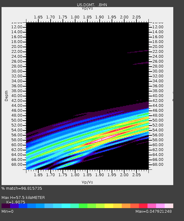
| Estimated Moho Depth: |
57.5 km |
| Estimated Crust Vp/Vs: |
1.91 |
| Assumed Crust Vp: |
6.438 km/s |
| Estimated Crust Vs: |
3.375 km/s |
| Estimated Crust Poisson's Ratio: |
0.31 |
|
| Radial Match: |
96.815735 % |
| Radial Bump: |
140 |
| Transverse Match: |
87.95158 % |
| Transverse Bump: |
264 |
| SOD ConfigId: |
2669 |
| Insert Time: |
2010-03-05 01:27:23.647 +0000 |
| GWidth: |
2.5 |
| Max Bumps: |
400 |
| Tol: |
0.001 |
|
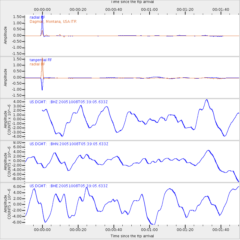
Signal To Noise
| Channel | StoN | STA | LTA |
| US:DGMT: :BHN:20051008T05:39:05.633Z | 1.1107949 | 2.2906245E-6 | 2.062149E-6 |
| US:DGMT: :BHE:20051008T05:39:05.633Z | 0.53668004 | 3.3687165E-6 | 6.2769554E-6 |
| US:DGMT: :BHZ:20051008T05:39:05.633Z | 0.7269184 | 1.554176E-6 | 2.1380338E-6 |
| Arrivals |
| Ps | 8.3 SECOND |
| PpPs | 26 SECOND |
| PsPs/PpSs | 34 SECOND |


