You are here: Home > Network List > US - United States National Seismic Network Stations List
> Station DGMT Dagmar, Montana, USA > Earthquake Result Viewer
DGMT Dagmar, Montana, USA - Earthquake Result Viewer
| Earthquake location: |
Pakistan |
| Earthquake latitude/longitude: |
34.4/73.5 |
| Earthquake time(UTC): |
2005/10/08 (281) 03:58:36 GMT |
| Earthquake Depth: |
10 km |
| Earthquake Magnitude: |
5.8 MB |
| Earthquake Catalog/Contributor: |
WHDF/NEIC |
|
| Network: |
US United States National Seismic Network |
| Station: |
DGMT Dagmar, Montana, USA |
| Lat/Lon: |
48.47 N/104.20 W |
| Elevation: |
0.0 m |
|
| Distance: |
97.5 deg |
| Az: |
358.438 deg |
| Baz: |
1.942 deg |
| Ray Param: |
0.04018928 |
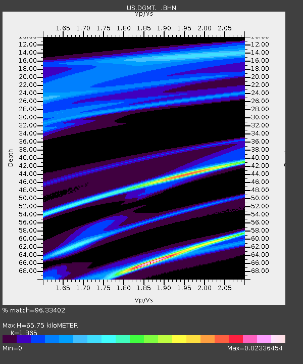
| Estimated Moho Depth: |
65.75 km |
| Estimated Crust Vp/Vs: |
1.87 |
| Assumed Crust Vp: |
6.438 km/s |
| Estimated Crust Vs: |
3.452 km/s |
| Estimated Crust Poisson's Ratio: |
0.30 |
|
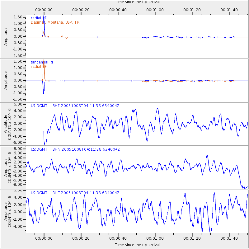
| Radial Match: |
96.33402 % |
| Radial Bump: |
86 |
| Transverse Match: |
93.88827 % |
| Transverse Bump: |
107 |
| SOD ConfigId: |
2669 |
| Insert Time: |
2010-03-05 01:27:24.707 +0000 |
| GWidth: |
2.5 |
| Max Bumps: |
400 |
| Tol: |
0.001 |
|
Signal To Noise
| Channel | StoN | STA | LTA |
| US:DGMT: :BHN:20051008T04:11:38.634004Z | 1.1575263 | 2.1235326E-6 | 1.8345436E-6 |
| US:DGMT: :BHE:20051008T04:11:38.634004Z | 0.7855179 | 1.877478E-6 | 2.390115E-6 |
| US:DGMT: :BHZ:20051008T04:11:38.634004Z | 0.88656914 | 2.1034054E-6 | 2.3725227E-6 |
| Arrivals |
| Ps | 9.0 SECOND |
| PpPs | 29 SECOND |
| PsPs/PpSs | 38 SECOND |


