You are here: Home > Network List > US - United States National Seismic Network Stations List
> Station DGMT Dagmar, Montana, USA > Earthquake Result Viewer
DGMT Dagmar, Montana, USA - Earthquake Result Viewer
| Earthquake location: |
Pakistan |
| Earthquake latitude/longitude: |
35.0/73.8 |
| Earthquake time(UTC): |
2005/10/08 (281) 03:58:12 GMT |
| Earthquake Depth: |
10 km |
| Earthquake Magnitude: |
5.7 MB |
| Earthquake Catalog/Contributor: |
WHDF/NEIC |
|
| Network: |
US United States National Seismic Network |
| Station: |
DGMT Dagmar, Montana, USA |
| Lat/Lon: |
48.47 N/104.20 W |
| Elevation: |
0.0 m |
|
| Distance: |
96.9 deg |
| Az: |
358.644 deg |
| Baz: |
1.674 deg |
| Ray Param: |
0.040380154 |
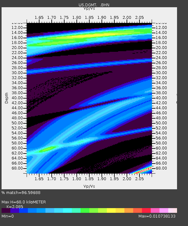
| Estimated Moho Depth: |
68.0 km |
| Estimated Crust Vp/Vs: |
2.09 |
| Assumed Crust Vp: |
6.438 km/s |
| Estimated Crust Vs: |
3.088 km/s |
| Estimated Crust Poisson's Ratio: |
0.35 |
|
| Radial Match: |
96.59688 % |
| Radial Bump: |
80 |
| Transverse Match: |
93.55092 % |
| Transverse Bump: |
115 |
| SOD ConfigId: |
2669 |
| Insert Time: |
2010-03-05 01:27:26.611 +0000 |
| GWidth: |
2.5 |
| Max Bumps: |
400 |
| Tol: |
0.001 |
|
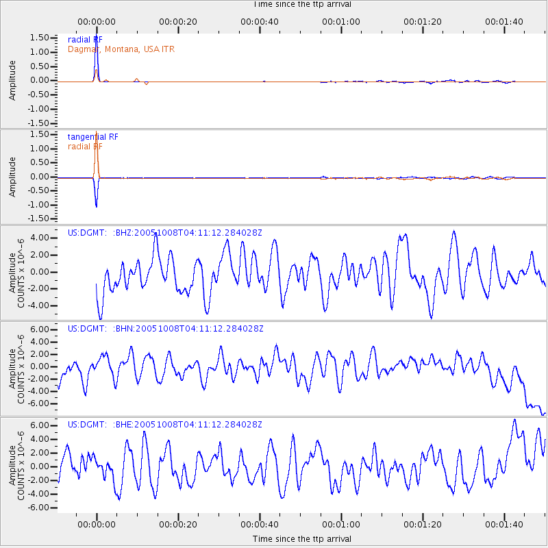
Signal To Noise
| Channel | StoN | STA | LTA |
| US:DGMT: :BHN:20051008T04:11:12.284028Z | 1.2708315 | 1.6371247E-6 | 1.2882311E-6 |
| US:DGMT: :BHE:20051008T04:11:12.284028Z | 0.9134344 | 1.5079761E-6 | 1.6508861E-6 |
| US:DGMT: :BHZ:20051008T04:11:12.284028Z | 1.1666815 | 2.3010628E-6 | 1.9723143E-6 |
| Arrivals |
| Ps | 12 SECOND |
| PpPs | 32 SECOND |
| PsPs/PpSs | 44 SECOND |


