You are here: Home > Network List > US - United States National Seismic Network Stations List
> Station DGMT Dagmar, Montana, USA > Earthquake Result Viewer
DGMT Dagmar, Montana, USA - Earthquake Result Viewer

| Earthquake location: |
Pakistan |
| Earthquake latitude/longitude: |
34.2/73.6 |
| Earthquake time(UTC): |
2005/10/08 (281) 03:57:19 GMT |
| Earthquake Depth: |
10 km |
| Earthquake Magnitude: |
5.9 MB |
| Earthquake Catalog/Contributor: |
WHDF/NEIC |
|
| Network: |
US United States National Seismic Network |
| Station: |
DGMT Dagmar, Montana, USA |
| Lat/Lon: |
48.47 N/104.20 W |
| Elevation: |
0.0 m |
|
| Distance: |
97.6 deg |
| Az: |
358.506 deg |
| Baz: |
1.86 deg |
| Ray Param: |
0.040154014 |
| Estimated Moho Depth: |
67.0 km |
| Estimated Crust Vp/Vs: |
2.10 |
| Assumed Crust Vp: |
6.438 km/s |
| Estimated Crust Vs: |
3.069 km/s |
| Estimated Crust Poisson's Ratio: |
0.35 |
|
| Radial Match: |
95.709496 % |
| Radial Bump: |
99 |
| Transverse Match: |
92.9133 % |
| Transverse Bump: |
104 |
| SOD ConfigId: |
2669 |
| Insert Time: |
2010-03-05 01:27:27.761 +0000 |
| GWidth: |
2.5 |
| Max Bumps: |
400 |
| Tol: |
0.001 |
|
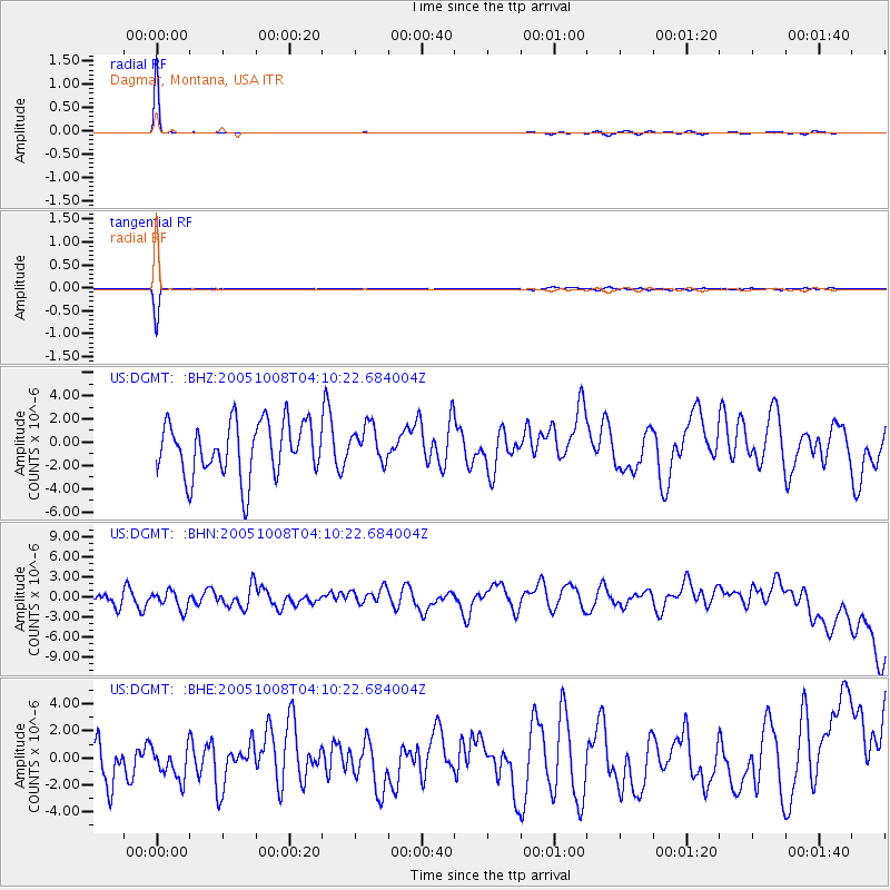
Signal To Noise
| Channel | StoN | STA | LTA |
| US:DGMT: :BHN:20051008T04:10:22.684004Z | 0.88473177 | 1.5242576E-6 | 1.7228473E-6 |
| US:DGMT: :BHE:20051008T04:10:22.684004Z | 0.545761 | 1.0942549E-6 | 2.0050074E-6 |
| US:DGMT: :BHZ:20051008T04:10:22.684004Z | 0.6638013 | 1.5460605E-6 | 2.3291013E-6 |
| Arrivals |
| Ps | 12 SECOND |
| PpPs | 32 SECOND |
| PsPs/PpSs | 43 SECOND |


