You are here: Home > Network List > US - United States National Seismic Network Stations List
> Station DGMT Dagmar, Montana, USA > Earthquake Result Viewer
DGMT Dagmar, Montana, USA - Earthquake Result Viewer

| Earthquake location: |
Pakistan |
| Earthquake latitude/longitude: |
34.5/73.6 |
| Earthquake time(UTC): |
2005/10/08 (281) 03:50:40 GMT |
| Earthquake Depth: |
26 km |
| Earthquake Magnitude: |
6.9 MB, 7.7 MS, 7.6 MW, 7.3 MW |
| Earthquake Catalog/Contributor: |
WHDF/NEIC |
|
| Network: |
US United States National Seismic Network |
| Station: |
DGMT Dagmar, Montana, USA |
| Lat/Lon: |
48.47 N/104.20 W |
| Elevation: |
0.0 m |
|
| Distance: |
97.3 deg |
| Az: |
358.513 deg |
| Baz: |
1.845 deg |
| Ray Param: |
0.0402335 |
| Estimated Moho Depth: |
47.25 km |
| Estimated Crust Vp/Vs: |
2.01 |
| Assumed Crust Vp: |
6.438 km/s |
| Estimated Crust Vs: |
3.199 km/s |
| Estimated Crust Poisson's Ratio: |
0.34 |
|
| Radial Match: |
95.41719 % |
| Radial Bump: |
92 |
| Transverse Match: |
95.19624 % |
| Transverse Bump: |
115 |
| SOD ConfigId: |
2669 |
| Insert Time: |
2010-03-05 01:27:28.855 +0000 |
| GWidth: |
2.5 |
| Max Bumps: |
400 |
| Tol: |
0.001 |
|
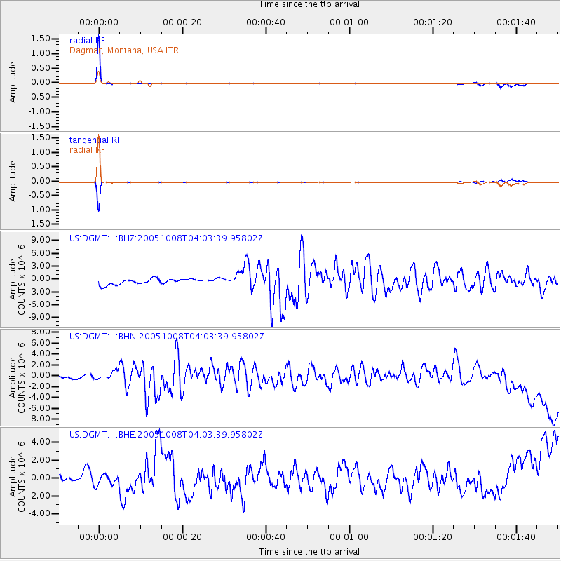
Signal To Noise
| Channel | StoN | STA | LTA |
| US:DGMT: :BHN:20051008T04:03:39.95802Z | 1.0710245 | 7.493203E-7 | 6.996294E-7 |
| US:DGMT: :BHE:20051008T04:03:39.95802Z | 0.6811334 | 5.9623414E-7 | 8.7535597E-7 |
| US:DGMT: :BHZ:20051008T04:03:39.95802Z | 2.4196393 | 1.5322079E-6 | 6.3323813E-7 |
| Arrivals |
| Ps | 7.6 SECOND |
| PpPs | 22 SECOND |
| PsPs/PpSs | 29 SECOND |


