You are here: Home > Network List > US - United States National Seismic Network Stations List
> Station DGMT Dagmar, Montana, USA > Earthquake Result Viewer
DGMT Dagmar, Montana, USA - Earthquake Result Viewer

| Earthquake location: |
El Salvador |
| Earthquake latitude/longitude: |
13.3/-89.3 |
| Earthquake time(UTC): |
2005/10/07 (280) 17:43:01 GMT |
| Earthquake Depth: |
50 km |
| Earthquake Magnitude: |
5.3 MB, 5.7 MW, 5.7 MW |
| Earthquake Catalog/Contributor: |
WHDF/NEIC |
|
| Network: |
US United States National Seismic Network |
| Station: |
DGMT Dagmar, Montana, USA |
| Lat/Lon: |
48.47 N/104.20 W |
| Elevation: |
0.0 m |
|
| Distance: |
37.2 deg |
| Az: |
343.605 deg |
| Baz: |
155.613 deg |
| Ray Param: |
0.076157056 |
| Estimated Moho Depth: |
56.25 km |
| Estimated Crust Vp/Vs: |
1.72 |
| Assumed Crust Vp: |
6.438 km/s |
| Estimated Crust Vs: |
3.737 km/s |
| Estimated Crust Poisson's Ratio: |
0.25 |
|
| Radial Match: |
97.75522 % |
| Radial Bump: |
106 |
| Transverse Match: |
48.634007 % |
| Transverse Bump: |
400 |
| SOD ConfigId: |
2422 |
| Insert Time: |
2010-03-05 01:27:32.320 +0000 |
| GWidth: |
2.5 |
| Max Bumps: |
400 |
| Tol: |
0.001 |
|
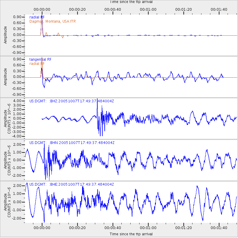
Signal To Noise
| Channel | StoN | STA | LTA |
| US:DGMT: :BHN:20051007T17:49:37.484004Z | 1.7861559 | 1.0749226E-6 | 6.018078E-7 |
| US:DGMT: :BHE:20051007T17:49:37.484004Z | 1.0015728 | 8.385048E-7 | 8.37188E-7 |
| US:DGMT: :BHZ:20051007T17:49:37.484004Z | 5.0660357 | 1.6636089E-6 | 3.2838477E-7 |
| Arrivals |
| Ps | 6.8 SECOND |
| PpPs | 22 SECOND |
| PsPs/PpSs | 29 SECOND |


