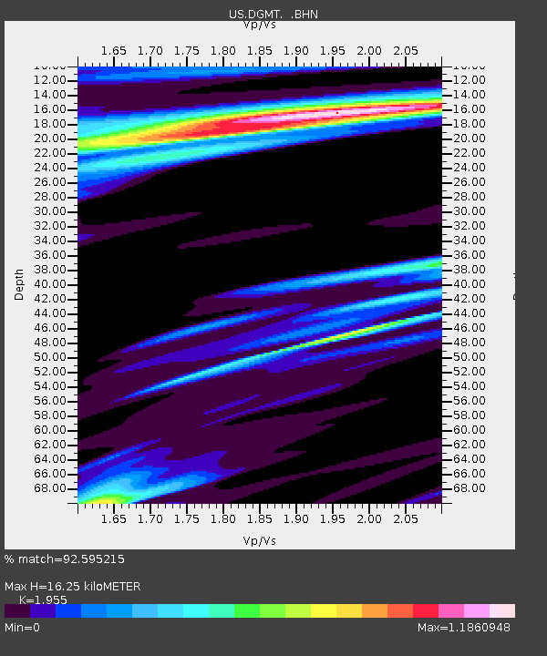
DGMT Dagmar, Montana, USA - Earthquake Result Viewer
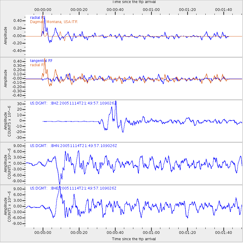
Earthquake location: Off East Coast Of Honshu, Japan
Earthquake latitude/longitude: 38.1/144.9
Earthquake time(UTC): 2005/11/14 (318) 21:38:51 GMT
Earthquake Depth: 11 km
Earthquake Magnitude: 6.7 MB, 6.8 MS, 7.0 MW, 6.9 MW
Earthquake Catalog/Contributor: WHDF/NEIC
Network: US United States National Seismic Network
Station: DGMT Dagmar, Montana, USA
Lat/Lon: 48.47 N/104.20 W
Elevation: 0.0 m
Distance: 74.3 deg
Az: 40.234 deg
Baz: 310.036 deg
Ray Param: 0.052454226
Estimated Moho Depth: 16.25 km
Estimated Crust Vp/Vs: 1.96
Assumed Crust Vp: 6.438 km/s
Estimated Crust Vs: 3.293 km/s
Estimated Crust Poisson's Ratio: 0.32
Radial Match: 92.595215 %
Radial Bump: 373
Transverse Match: 73.00783 %
Transverse Bump: 400
SOD ConfigId: 2448
Insert Time: 2010-03-05 01:27:33.807 +0000
GWidth: 2.5
Max Bumps: 400
Tol: 0.001

Signal To Noise

ChannelStoNSTALTA
US:DGMT: :BHN:20051114T21:49:57.109026Z0.98673991.1588355E-61.1744083E-6
US:DGMT: :BHE:20051114T21:49:57.109026Z1.47869291.06695E-67.215494E-7
US:DGMT: :BHZ:20051114T21:49:57.109026Z23.1613166.1805576E-62.668483E-7
Arrivals
Ps2.5 SECOND
PpPs7.2 SECOND
PsPs/PpSs9.7 SECOND