You are here: Home > Network List > US - United States National Seismic Network Stations List
> Station DGMT Dagmar, Montana, USA > Earthquake Result Viewer
DGMT Dagmar, Montana, USA - Earthquake Result Viewer
| Earthquake location: |
Kuril Islands |
| Earthquake latitude/longitude: |
46.6/153.3 |
| Earthquake time(UTC): |
2006/11/15 (319) 11:14:13 GMT |
| Earthquake Depth: |
10 km |
| Earthquake Magnitude: |
6.5 MB, 7.8 MS, 8.3 MW, 7.9 MW |
| Earthquake Catalog/Contributor: |
WHDF/NEIC |
|
| Network: |
US United States National Seismic Network |
| Station: |
DGMT Dagmar, Montana, USA |
| Lat/Lon: |
48.47 N/104.20 W |
| Elevation: |
0.0 m |
|
| Distance: |
63.8 deg |
| Az: |
46.367 deg |
| Baz: |
311.41 deg |
| Ray Param: |
0.059314452 |
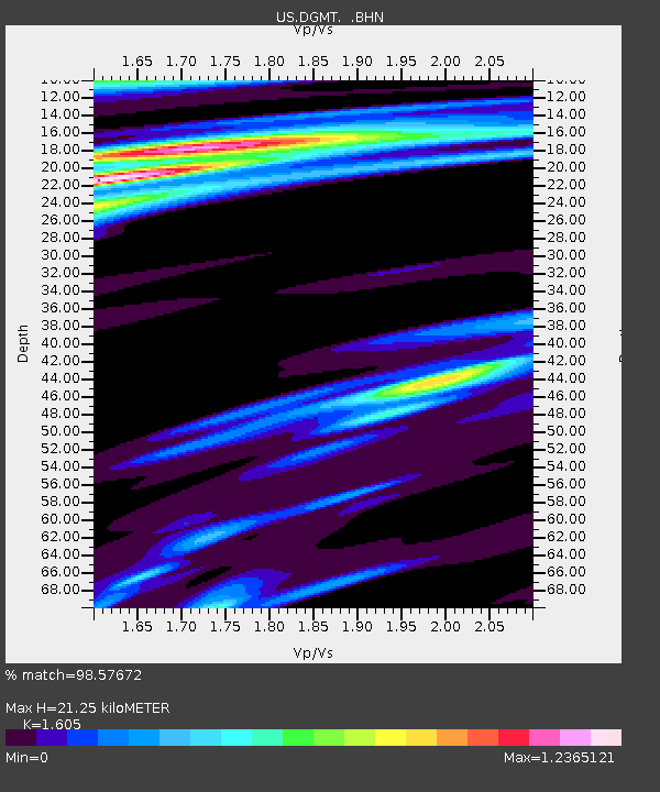
| Estimated Moho Depth: |
21.25 km |
| Estimated Crust Vp/Vs: |
1.61 |
| Assumed Crust Vp: |
6.438 km/s |
| Estimated Crust Vs: |
4.011 km/s |
| Estimated Crust Poisson's Ratio: |
0.18 |
|
| Radial Match: |
98.57672 % |
| Radial Bump: |
288 |
| Transverse Match: |
92.91993 % |
| Transverse Bump: |
400 |
| SOD ConfigId: |
2564 |
| Insert Time: |
2010-03-05 01:27:45.302 +0000 |
| GWidth: |
2.5 |
| Max Bumps: |
400 |
| Tol: |
0.001 |
|
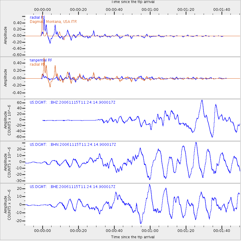
Signal To Noise
| Channel | StoN | STA | LTA |
| US:DGMT: :BHN:20061115T11:24:14.900017Z | 2.6001577 | 1.7061593E-6 | 6.561753E-7 |
| US:DGMT: :BHE:20061115T11:24:14.900017Z | 0.7289204 | 4.656335E-7 | 6.3879884E-7 |
| US:DGMT: :BHZ:20061115T11:24:14.900017Z | 9.045976 | 3.3092651E-6 | 3.6582733E-7 |
| Arrivals |
| Ps | 2.1 SECOND |
| PpPs | 8.2 SECOND |
| PsPs/PpSs | 10 SECOND |


